A Rare Find – Benchmark Found near Chantry Flat

Posted on May 10, 2012 – Written by Chris Kasten

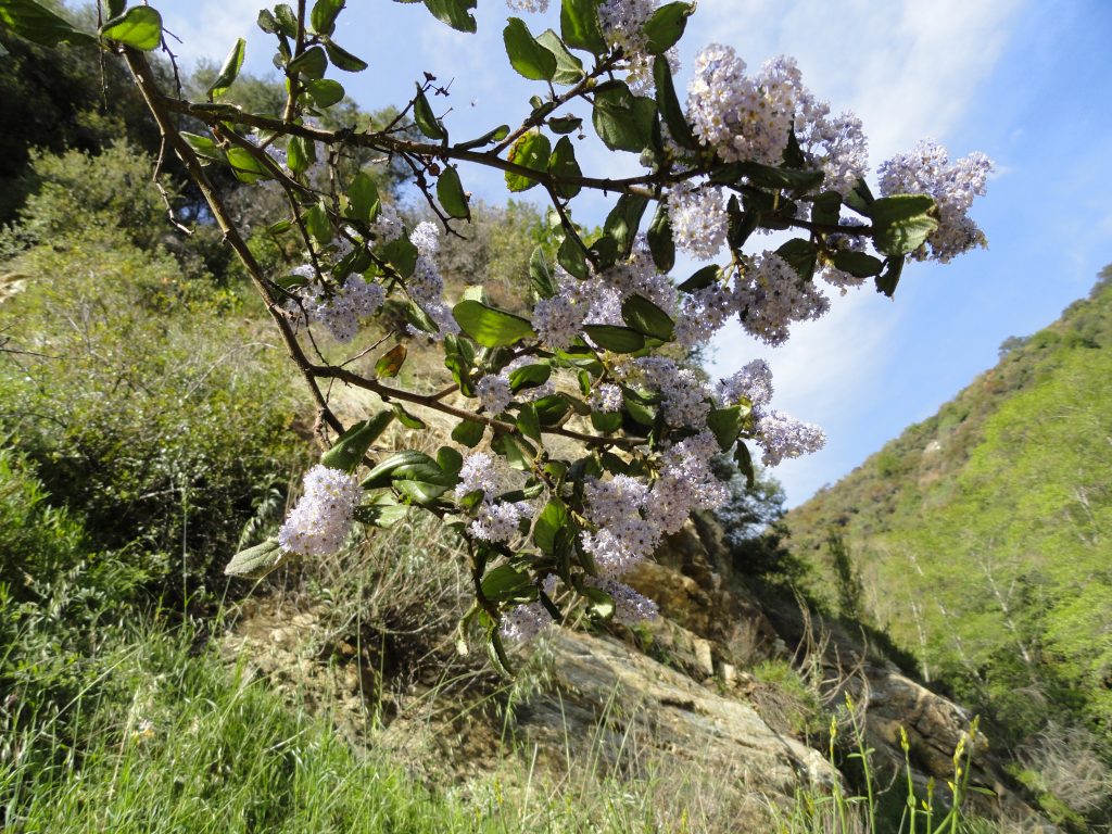
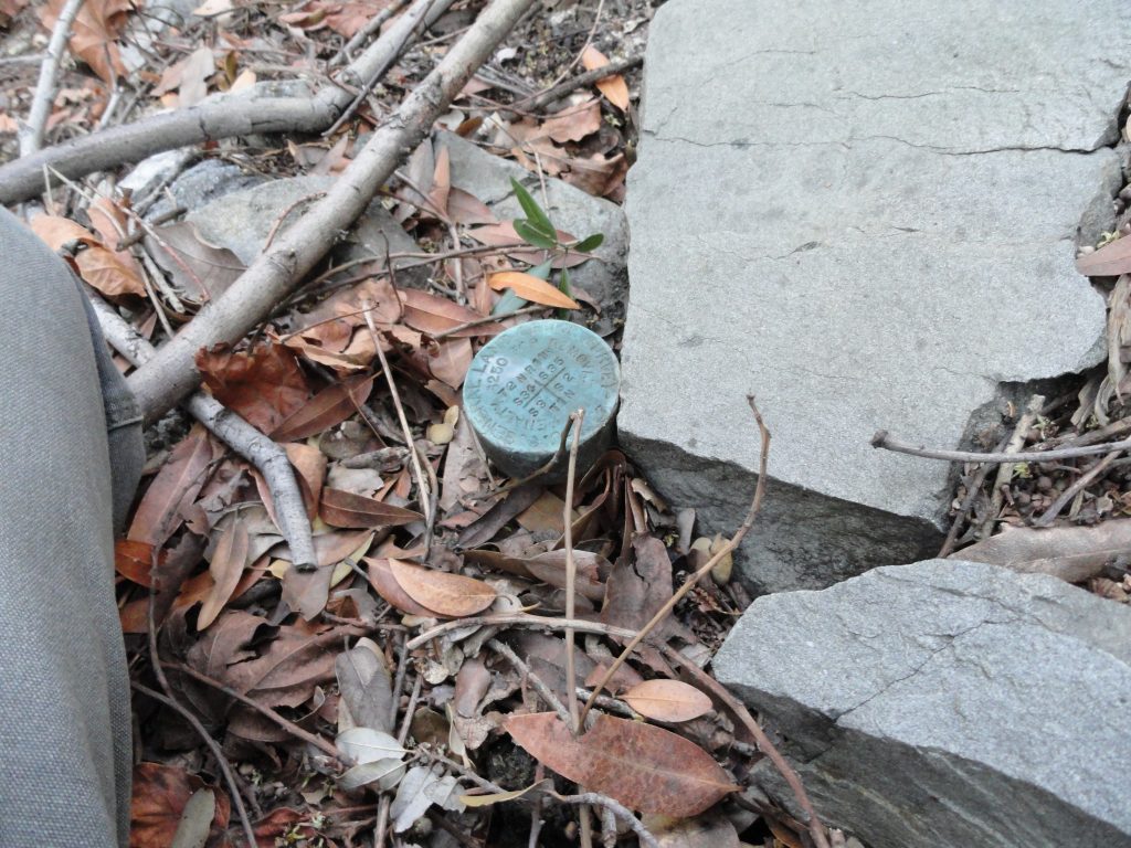
Here’s the benchmark for the corner section that appears just within feet of the old Monrovia Peak Trail. This corner section benchmark (monument) is attached to the end of a pipe.  Richard Loe and I found this 1927 benchmark entirely by accident, when sunlight happened to be shining on it at just the right moment!

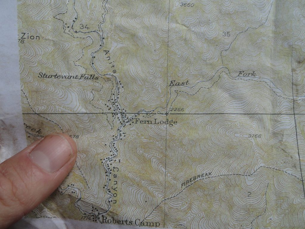
Here’s an old topographic map of the Big Santa Anita Canyon showing lots and lots of cabins that were still here before the great flood of 1938 and the Monrovia Peak Fire of 1953. Where those lines cross, to the upper right of my thumb, is the range and township monument (benchmark) that Richard and I found. Look how close it is to the old Monrovia Peak Trail heading up the East Fork tributary canyon.

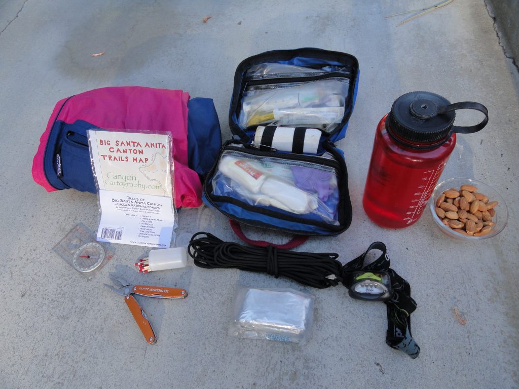
A rare find – 1927 benchmark found near Chantry Flat.  Check out what was found while traveling up the old East Fork Trail, which once ran from Fern Lodge in the Big Santa Anita Canyon to Spring Camp near Monrovia Peak.   This benchmark is dated 1927.  While x-country hiking with Richard Loe, we found this oxidized brass range and township marker located just below the old East Fork trail about 80-100′ up from the stream bed.    If you look closely, it’s possible to see that it was installed by the U.S. General Land Office surveyors.  See the location of this marker on the old topographic map, lower image.  If the light cast on the mountainside hadn’t been just right…. and if I hadn’t looked in just the exact location at that moment, it would have been quite likely we would have just hiked right on by!  It’s amazing to me that rockslides and  the movement of soils over the last 85 years hadn’t just buried this cartographer’s treasure from the past.  Upon closer inspection, it was discovered that the benchmark “cap” was affixed to a galvanized steel pipe driven into the mountainside.  There are undoubtedly other markers to be found by those hiking cross-country in the front-country canyons of the San Gabriel mountains.


Consider Bringing Just a Little Extra on Your Next Hike….

Posted on April 13, 2012 – Written by Chris Kasten

The 10 essentials

When out hiking or biking the beautifully rugged canyons of the San Gabriels, it’s tempting to just go without any extras.  No pack, nothing in our hands, nada.  Yet, here’s something to consider.

The Big Santa Anita Canyon, like many front-country canyons, is tantalizingly close to the the urban expanses of pavements, cars and cell phone reception.  In no time, well maybe 20 minutes, you’re at the trailhead and onto single-track foot trails or perhaps ambling x-country up a steep canyon.  The mindset of urban and suburban thoughts barely have the time to shift to the contemplative, natural thought processes of traveling in relatively open and wild places.  Your body’s muscle memory hasn’t quite caught up either.  It’s all happening so fast.

What a gift this is to have such quick access to the canyons, ridge lines and slopes that are so dear to our hearts.  More and more people each year are discovering the same miracle of this unique geography.  And although we continue to spontaneously take off for the mountains from our suburban springboards, doing that mental and physical shift over and over, again can be met with surprises at any stage in our lives.

Eventually we all get caught out in the dark without a flashlight during those autumn days when the amber light dwindles rapidly to long nights.  We run out of water on a hot and exposed ridge line in mid-summer.  We end up soaked to the bone on a frigid winter day that started out sunny and all too quickly became windy and rainy before returning to the trailhead.  We thought that the trail certainly should have peeled off the ridge by now or that we may have missed the junction just below the campground that we really need to find before starting dinner and getting the tent set up.  If I’d brought a detailed map of the area along with a compass, maybe I’d already be there and fed. On and on it goes.  Rarely does nature bail us out of our mistakes.  And …. maybe, if you’re lucky, you’ll run into someone who is prepared for being out here.  I hope they get here fast!

Instead of depending on someone else to help you out of the unforeseen, consider being a guiding light to someone else who just might need you!  By carrying a small number of essential items, you may just end up being a blessing to a complete stranger in an entirely unpredictable situation that might have ended tragically had you not been there.  You just never know.

So, what should you have on you, regardless of the time of year?  Here’s a short list.

A well-stocked first aid kit, with the knowledge of how to use it.  Add a Sawyer Extractor kit to your first aid kit.

Flash light or headlamp with fresh batteries.

At least a liter of water for each person travelling.  Two liters if the weather’s hot.

A detailed map of the area where you’ll be travelling.  Review your map prior to leaving the trailhead!

An orienteering compass with transparent base plate.  If you have a GPS device, still bring a reliable compass.

Light jacket.  PolarTec or another type of synthetic fiber is a good idea in case you get wet.

Space blanket.  This is a very tightly folded, silvery coated sheet that you could wrap yourself into if you had to spend the night unexpectedly .  Once you take it out and unfold it,  you’ll never get it back in the original package!

Lightweight poncho or rain gear.

50′ of parachute cord or equivalent.

Waterproof matches and/or butane lighter.

Cell phone.  If you’re in a spot where you might have reception, you’d be able to keep the panic level down at home, while letting them know that you’re just late and o.k.  If you need Search & Rescue, you can reach them as well.

Chantry Flats Cabins – How Did They Get Here?

Posted on April 5, 2012 – Written by Chris Kasten

An idyllic scene of cabins found along the trail in the Big Santa Anita Canyon. They are privately owned by individuals and families within the U.S. Forest Service Recreational Residence Program. The special-use permits for these cabins prohibits them being rented out.  Please respect the privacy of cabin owners.

As of  January 2020, Maggie Moran became the new owner of Adams Pack Station!  Please call her at the Pack Station (626) 447-7356 with your questions regarding their general store and cabins currently for sale.   The Pack Station is currently developing an Instagram page as well as a new website.  As soon as these are up and running, I’ll update this blog with their links.  Thank you –     Chris

When first hiking into the Big Santa Anita Canyon along most any of the  trails, one can’t help wondering about the origins of the little Chantry Flats cabins that appear alongside the paths and streams.  Construction of these early dwellings dates back to the early teens and 1920′s.  Back then, during the Great Hiking Era, the U.S. Forest Service was actually encouraging the building of cabins on “never before settled” suitable locations in a number of national forests throughout the United States.  In the Big Santa Anita Canyon, all kinds of potential cabin “sites” were discovered and developed.  Typically an Angeles National Forest ranger would hike to the potential site with the cabin builder applicant for approval of a special use permit or not.   Back then, the Chantry Road to the current trailhead did not exist.  The road would not be built to Chantry Flat until 1935.  Therefore, you would hike all the way from Sierra Madre, thus adding about 4 miles each way to your destination.  It was over 8 miles one way to Sturtevant’s Camp, versus the current 4 mile trip in!  There were motivated hikers, to say the least.

Maggie Moran leads her pack train down the Big Santa Anita Canyon on the Gabrielino National Recreation Trail. This is how supplies are transported between Chantry Flat and the private cabins along the hiking trails. Photo taken near Fern Lodge, just downstream from Sturtevant Falls.

When the cabin building program began, “recreational resident cabins” (U.S. Forest Service language) numbered over 220 + in the Big Santa Anita and Winter Creek canyons.  Materials for these cabins was hauled in on mules and people’s backs for the numerous building projects.  Pack trains travelled the narrow mountain trails seven days a week through the busy construction years.  Not only cabins were being built, but trail resorts were springing up as well!  Five resorts alone were in existence during this period.  Hoegees, Roberts’ Camp, First Water, Fern Lodge and Sturtevant’s were enormously popular for groups of hikers seeking an overnight experience.  Information about the colorful events from the camps is a separate subject entirely.  Just imagine how the canyon would have sounded and looked during the evenings as lanterns flickered through the little windows amongst the trees and reflecting stream.

As for the cabins, a number of natural and man-made events pared down the initial number of structures dramatically.  A great flood that took place in 1938 (the 38′Flood) washed out many cabins, not only in the Big Santa Anita, but in other front country canyons such as the Arroyo Seco and San Gabriel Canyon as well.  The next sizable event for the canyon was the 1953 Monrovia Peak Fire, which started up at Spring Camp near the summit of Monrovia Peak.  More cabins succumbed to this catastrophic fire which burned for weeks.  In 1969, yet another flood occurred, which took out some more of the cabins.  Amongst all this, occasionally cabin owners have had a part in accidentally burning down their own dwellings.  Although uncommon, it has happened even into recent times.  Today, there are less than 79 cabins left standing in the Winter Creek and Big Santa Anita canyons.

The cabins are privately owned and are a labor of love to say the least.  To this day, supplies are hauled in by the Adams Pack Station at Chantry Flats.  Items such as propane, lumber, groceries, furniture, roofing and more are taken to the trailside cabins by the pack string of mules and donkeys.  Also,  a frequent foot patrol takes place to ensure the security of the cabins.  The cabins are unavailable for rent to the general public.  If you’re interested in purchasing one, go to the Adams Pack Station website (www.adamspackstation.com) to inquire about cabins that may be up for sale.  The cabins are located on public land, so cabin owners must comply with U.S. Forest Service regulations in regard to everything from paint color, type of roofing, sanitation practices and the gathering of downed wood.  When you’re out hiking or backpacking, please respect the privacy of the cabins.   Many people have been drawn to the Big Santa Anita Canyon due to its’ popularity as one of most scenic L.A. County waterfall hikes.  These unique little cabins are a sweetly unexpected find for the eyes.

If you’re interested in ever spending the night in a cabin, there is one place where you can rent.  Sturtevant Camp, located a couple of miles upstream from Sturtevant Falls, is available to individuals, couples and groups by reservation.  The camp has comfortable, clean amenities and is open throughout the year.  Check out the Adams Pack Station website adamspackstation.com for details on how to make this happen.

Chantry Flats Check Dams – During the Construction Years

Posted on March 28, 2012 – Written by Chris Kasten

A tractor shovel begins trenching a site for a foundation of a check dam. This spot is located just downstream from Sturtevant Camp.  Circa 1962

Here are some photos of the Chantry Flats check dams during their construction back in the early 1960′s. The U.S. Forest Service and Los Angeles County Flood Control District teamed up to engineer and construct these Lincoln Log type structures in many of the front country canyons of the Angeles National Forest.  These structures were designed to keep the stream bed’s ever-moving alluvium “in check” with hopes of reducing the accumulation of sand and rock in the Big Santa Anita’s reservoir further down canyon. Regardless of how they’ve performed, they’re here to stay for the foreseeable future.  The paved fire road that you begin your descent down into Robert’s Camp is the beginning of the construction road that was bull dozed all the way past Sturtevant Camp.  Another road was also built on up the Winter Creek and beyond Hoegee’s trail camp.  Today you can still make out the remnant switch backs of the “Burma Road” which climbed up and past Sturtevant Falls.  Look for the non-native Italian cypress, pines and even eucalyptus trees that were planted on the abandoned road bed after the dams were installed.  The Big Santa Anita Canyon Trails Map depicts the location of the abandoned Burma Road.  The map is available at Adams Pack Station or canyoncartography.com    Following the road is a hazardous proposition any time of year, so be especially careful for drop-offs, rattlesnakes, etc.  If you’ve hiked on past Cascade picnic area, you’ll strain to imagine that a road ran through here, wide enough to accomodate cement mixers, skip loaders, cranes and more.

A check dam nears completion at Cascade Picnic Area, Big Santa Anita Canyon. A gunite cap will be added next.  Circa 1963.

The destruction of pristine riparian environments would be unthinkable in our day and age.  Yet, during the late 1950′s, this type of project was considered prudent land management and protection of watersheds.  Essentially, the dams have changed the natural hydraulic grade of much of the Big Santa Anita Canyon and Winter Creek.  The dams have created a stair-step type of profile in sections of the canyon bottom.  Behind each dam are thousands of cubic yards of alluvium (sand, gravels and boulders) that are for now “stuck” in a static location.  One day nature will have her way and there will be a phenomenal movement of material that will wash downstream.  The engineers referred to this material behind each dam as a “debris cone.”  In 1969, an El Nino storm pattern brought torrential rainfall to Southern California.  One night during the ’69 Flood, a number of the smaller “sill dams” blew out.  A sill dam is the lower (smaller) dam that you’ll often see just below or downstream of the larger check dam.  The sill dam’s function is to protect the foundation of the larger check dam.  Anywhere upstream of Cascade picnic area, you’ll notice that all the check dams have their accompanying sill dams.  Anywhere below the confluence of the North Fork, you’ll notice that these sill dams are missing.  Look carefully and notice the exposed foundations of the dams.  One day they may collapse.  This all happened during one set of storms in ’69!  Slowly, nature has been healing from all this damming of the canyon.  Decades later you can see the ivy, black berry bushes, mosses, fallen trees and sharp-edged boulders softening the scene.  Canyon wrens flit back and forth into the aging rip-rap after spring floods ring through the canyons.  Stout, black rattlesnakes gently drape their coils off the edge of the walls of the dams during the warm, drowsy days of August.  The canyon is gradually claiming all the dams.  We’re just hiking and feeling all this. in one part of this long, long timeline.

November, 2015.   I recently heard from Dennis Logue, a member of the construction crew who built both the road and dams starting back in 1958.  We began corresponding.  He graciously has given permission for me to add his memories in the form of several letters to Canyon Cartography, describing the project and some of the colorful characters that were involved.   Here they are:

The first letter from Dennis. Red Shangraw & Elsie the deer

Dennis Logue is seen working on uppermost check dam in Big Santa Anita Canyon. July 1962. He’s the third man out to the left near the future spillway.

Second letter describing challenge of road building and method of applying gunite.

Third letter describing return of riparian plants and local animals. Response to 1969 Flood.

Fourth letter covering Dennis’ experience working with the crew on dams along with details on excavating for check dams.

Big Santa Anita Canyon Loop

Posted on March 20, 2012 – Written by Chris Kasten

Wild lilac blossoms, green grasses and blue skies preview the start to a beautiful day of hiking the Big Santa Anita Canyon Loop.

The Big Santa Anita Canyon Loop is perfect for day hiking as well as backpacking throughout most of the year.  Whether you’re in search of being alongside a rushing mountain stream,  seeing one of the most beautiful waterfalls in the Angeles National Forest or getting a good hill climb with vistas out toward the high country, this hike’s for you!   Let’s say that you decide to do the trip counter-clockwise, then you’d start at the Gabrielino trailhead, dropping 0.6 of a mile down the paved road (gated) to Robert’s Camp.  Here you’ll cross the green metal and wood hikers’ bridge, which has been here since 1950.  Robert’s Camp is located at the confluence of the Big Santa Anita Canyon and Winter Creek.  Once a trail resort during the Great Hiking Era, it’s now an important junction for trail users.  On this loop trip, we’ll head toward Sturtevant Falls and Spruce Grove.  Less than 0.8 of a mile up canyon from here you’ll come to idyllic Fern Lodge junction.  Dotted with picturesque cabins nestled along the verdant banks of the stream, Fern Lodge is a beauty spot of large canyon oaks leaning out over the trail.  Stands of white alder grow tall and straight, nestled in close along the tumbling stream.  Boulders, some bright white, others speckled with black mica, and still others solid gray or banded in alternating layers make up the jumbled stream bed.  At this junction you can head up the Upper Falls Trail, which is for hikers only, if you want to see Sturtevant Falls from up above.  Also, you can take the Gabrielino trail, which is for both hikers, pack animals and mountain bikes.  Regardless of your choice, both these trails rejoin a mile up canyon at Falling Sign Junction.  If you choose to take the Upper Falls trail, not only will you be rewarded with a great view of Sturtevant Falls, there will be a series of rock-ribbed pools that you’ll pass along.  Some of these are great for cooling off during the warmer months of the year!  The water’s chilly, usually never reaching the 60 degree mark.  Past the pools, the canyon stays wild and narrows down into a rugged and twisting place, shaded by bay trees and maples.  If it’s the right time of day, there can be a gold-green light filtering down through the trees to the canyon bottom.

A couple of stream crossings further up, your trail loops back up toward the Gabrielino trail at Falling Sign junction.  Here you’ll hook around to your right, continuing on to Cascade Picnic Area.  This next half mile takes you into both Maple and Tiger Lily canyons.  You’ll also have a great view down into the canyon from where you’ve just been.  There’s a beautiful overlook that you round, just prior to dropping down into Cascade picnic area.  At Cascade, you’ll find a lonesome little table and a call box (for reporting emergencies).  Big Cone Spruce begins to make its’ presence here along with mature Canyon Live Oak arching out and across the stream.  Cascade’s name speaks for itself, you won’t be disappointed.  Up canyon from here you’ll climb up and over nine check dams to Sturtevant Camp.  To many, this is often the steepest part of the trip to Spruce Grove campground and Sturtevant’s.  In 0.7 of a mile, you’ll reach Spruce Grove campground for those wishing to spend the night on the ground.  It’s located at 3,000′ in elevation alongside the year-round stream.  It is well-shaded, mostly by bay trees and occasional spruce.  There are seven picnic tables, metal rings for campfires, Klamath stoves (flat metal plate to cook on) and restrooms.  Make sure to obtain a fire permit prior to your trip!  They’re free and you’ll be required to have one if you’re planning to use a backpacking stove or build a fire.  Just 0.3 of a mile above the camp is an important trail junction. At this junction, just below Sturtevant Camp, one can turn right and head toward Newcomb Pass and on into the West Fork of the San Gabriel River.  The way we’ll head on this trip is to the left and up and over the check dam.  If you need drinking water, head up into Sturtevant’s.  Here they have a drinking fountain with potable water.  A real luxury this far in!  Don’t forget to check out the big rope swing and have a look at the place.  Sturtevant Camp has been here since 1893 and continues to be available as an overnight destination.  Reservations are required and can be made through the Adams Pack Station website:   www.adamspackstation.com   This is a very cool place to spend some time in the California of old.

From  Sturtevant’s, head back down to the trail junction above the dam and head across the stream, where you’ll bypass the camp and travel a very short distance upstream before arriving at the Upper Mt. Zion trail junction.  Here you’ll still be across from the camp.  Peel off to the left, climbing into a watered side canyon.  The Mt. Zion trail contours northeast facing hillsides, climbing 300 feet in just over a mile.  Along this stretch, you’ll have vistas out toward Twin Peaks and Mount Waterman.  Once at the saddle (watershed divide) you have the option of doing a quick side trip to the summit of Mt. Zion in all its’ shaggy chaparral glory.  Heading over the saddle, you’ll drop steeply down into the Winter Creek.  You’ll be out in the chaparral, with lots of options for views down into the San Gabriel Valley, Chantry Flats and across to Manzanita Ridge.  After a 1,000′ drop in elevation, you’ll encounter the Lower Mt. Zion trail junction.  If you want to see Hoegees campground, turn left and head downstream a very short distance.  This is also a beautiful campground, replete with a magnificent oak canopy and over 18 campsites.  We’ll turn right at the junction, heading upstream a short distance, crossing the stream and then encountering yet another junction.  This junction’s really important.  Make sure to turn left, back toward Chantry Flat.  Make sure you don’t accidentally head toward Sierra Madre and Mt. Wilson!

From this junction, head left and into a drainage that sometimes has water skimming down a rock face you can reach out and touch.  Keep climbing, at times steeply, until after less than a third mile the trail will level out.  I mean really level.  You’ll love coming back into Chantry Flats on this Upper Winter Creek trail.  Near the end of the trail, you’ll come around a ridge that’ll afford you a view of the Chantry Flat area.  You’ll see the parking area, people trudging back up the paved road where you began your hike hours earlier, hear the sounds of folks enjoying the picnic area and maybe even hear live music coming from the Adams Pack Station if its’ the weekend.  Eventually, after crossing the tranquil little stream in San Olene Canyon, your trail will intersect the paved San Olene truck trail coming up out of the picnic area.  Make sure to turn left on the road and make your easy descent into the parking area.  If you’re hungry or thirsty, make sure to stop by the Adams Pack Station for drinks and good food!  Also, you can pick up good maps of the canyon’s hiking trails and check out their book display.   Big Santa Anita Canyon Trails Map is a large-scale map that will cover your entire hike.  This map is available at the Pack Station or you can purchase it online at www.canyoncartography.com   By the time your day’s over, you will have gotten over 9 1/2 miles behind you!  This Big Santa Anita Loop is a great way to spend your day or weekend.