Chantry Flat Map … How To Navigate It

Posted on August 19, 2015 – Written by Chris Kasten

If you’ve decided to pack a Chantry Flat Map, it’s important to have an orienteering compass along for your trip.  One of the key advantages of carrying a compass is the ability to orient your map to the landscape and

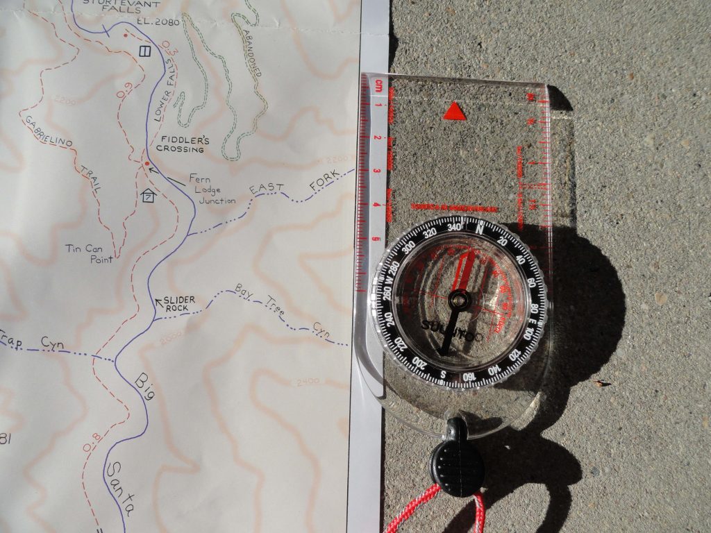
Align orienteering compass to map’s neat line for getting your map synchronized with the land. This placement of getting the map “right” with the earth is the first step in seeing where you are in the greater picture of things.

to ultimately discover just where you happen to be within the confines  (neat lines) of the map’s image.  Knowing where you are on any map while out hiking or biking adds greatly to your confidence in traveling the trails between Chantry Flats and Mt. Wilson. The orienteering compass you see here is inexpensive and requires no batteries.  If you travel with GPS, bringing along a compass, as well, might be a good back-up.  If you travel with your smart phone,  utilizing the north arrow function will suffice as well.  Just make sure that you line up the edge of your phone with the map’s north-south neat line as shown in the image to the left.  Rotate the map & phone together to “sync” your map to the landscape.  If you decide to buy a compass, they are available at most outdoor retailers, such as REI and Sport Chalet.

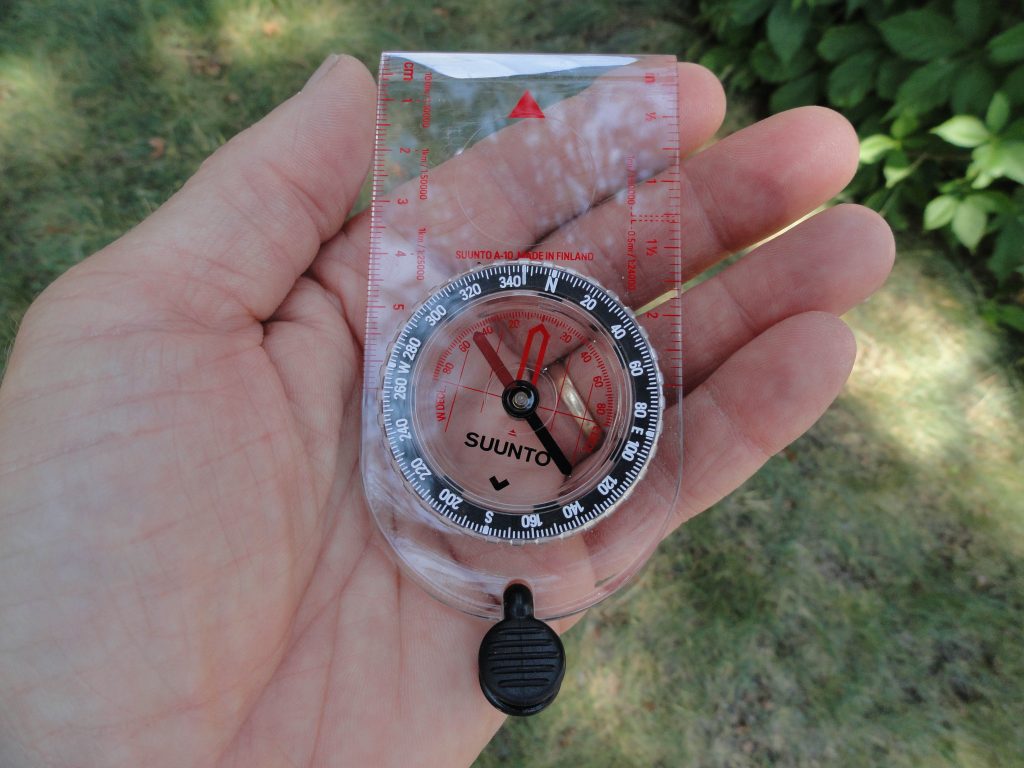
This orienteering compass is an essential item to pack when out hiking and biking on our local trails. It is inexpensive (approx. $16.00) and never needs batteries. Use it to orient your map to the lay of the land, as well as locating where you are within the map’s image

The key challenge that most travelers have in using an orienteering compass is dealing with the concept of declination.  Declination is the magnetic, angular difference between the earth’s geographic north pole and the “magnetic” pole, located well north of Hudson’s Bay, Canada.  The compass needle naturally points toward the magnetic pole.  To get your map to synchronize with the earth, the north-south edge of your map has to be parallel with the north to south lines of longitude on the earth’s sphere.  So, how do you make this happen?

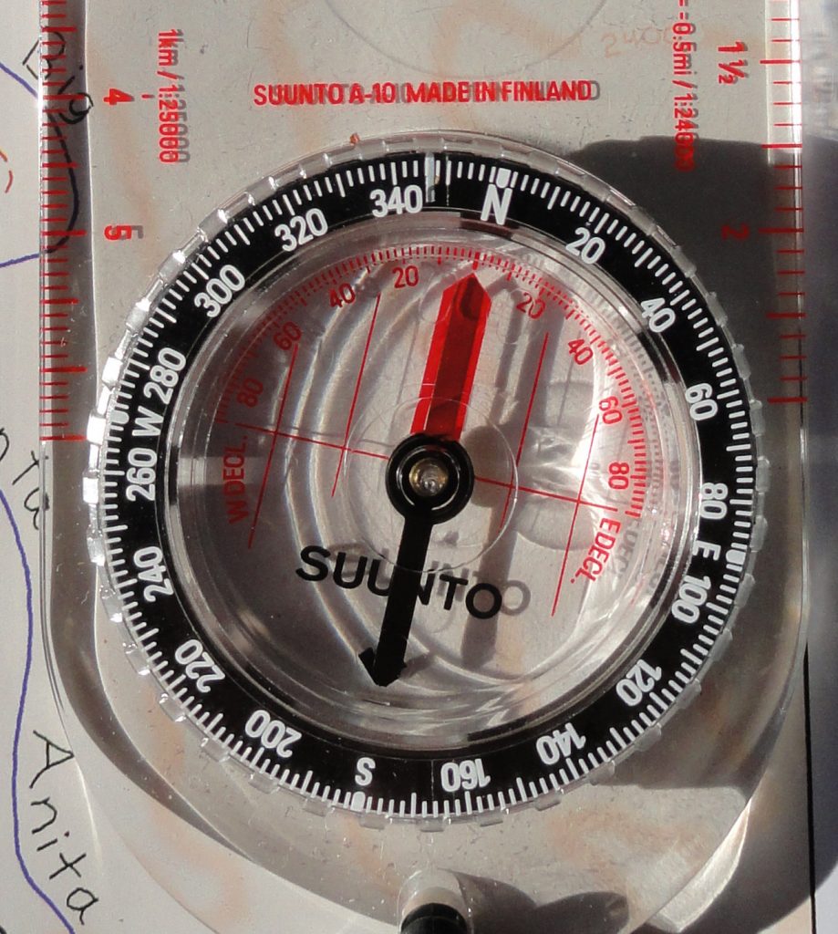
For areas in the front-country of the San Gabriel mountains, specifically Chantry Flats, there’s about 13 degrees of difference between the geographic north pole and the magnetic pole.  Looking at the detail of the compass dial photo, you’ll see that instead of 360 degrees being lined up with the index mark (North), 13 degrees of declination have been subtracted to equal just about 347 degrees, instead.  This is an easterly correction that works for all of California, with an increase as you head north, say in the Sierra Nevada range.  Just twist the dial to the right to make your adjustment. Next, slowly turn your compass, keeping it level as you can, until the red end (magnetized) of the needle is

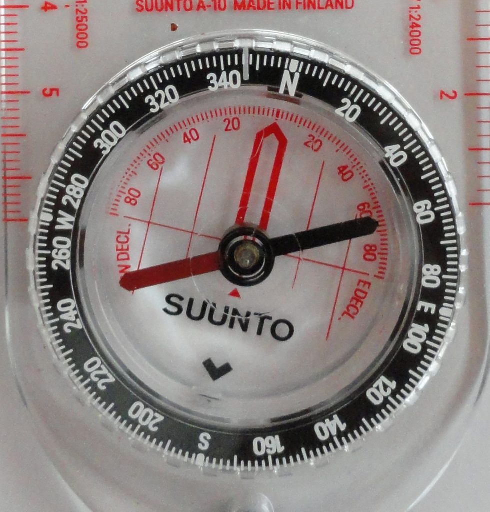
Dial on clear baseplate. Directional degrees are depicted in white numbers on black background of outer lying dial. Declination in degrees, east and west, appear on red scale. Dark red half of needle is magnetized, pointing toward magnetic north pole. www.CanyonCartography.com

superimposed over the red outline within the dial’s face.  Once this is done, the edges of the transparent baseplate are now lined up with the north-south lines of longitude.  The top of your compass is facing north.  Now take your map and turn it to the point where the map’s edge, left or right side, are parallel with the compass baseplate.  Another photo shows you what this looks like.  Voila!  Your map is now oriented to the actual mountains and canyons of Chantry Flats and Mt. Wilson.  Often, just doing this, will make a huge difference in determining just where you are on the map. In the next article, we’ll go over how to sight on an object, such as a mountain top, and determine just where you happen to be on the map.

Compensating declination for true north is accomplished by aligning the compass needle with the red outline inside the dial. Notice how needle is directly over this outline. Good!

Chantry Flats Hiking Trails Updated Map

Posted on December 31, 2014 – Written by Chris Kasten

If you spend time on the trails above Arcadia and Sierra Madre, here’s the Chantry Flats hiking trails updated map that covers the area between Chantry Flats & Mt. Wilson.    It’s comes in either a weather-proof paper form with free shipping or as a downloadable pdf image through canyoncartography.com.   It is completely hand-drawn and accurate.   This two-sided map is also available at the Adams Pack Station General Store.    When you’re up at the Chantry Flats trailhead,  just head over to the Pack Station, located on the other side of the picnic area from the upper parking lot.   As of January 2020, Maggie Moran is the new owner of Adams Pack Station.     She’s made some significant improvements to the operation, such as a new deck for seating.  The Pack Station’s General Store is a great place to enjoy delicious food and a cold drink at the end of your hike!    Limited parking is also available.  The Pack Station can be reached at (626) 447-7356.    Thanks –   Chris

A grouping of baby blue eyes as seen in the cool, late afternoon light. Stream side trail between Roberts’ Camp and Fern Lodge Junction, Big Santa Anita Canyon.

The same map area is still depicted on the front page as the earlier versions.  Just flip the map over and continue on your trip to Mt. Wilson.  The entire Mt. Wilson Loop is found on this map, front and back.   Besides the coverage area now being nearly twice as large, index contour lines (200′ intervals) have been added to depict shape and steepness of slope.  Contours have been added at 50% opacity to prevent their competing visually with trail, stream and print detail. The Spring wildflowers are out in abundance.   Go to www.simpsoncity.com/hiking/plants/ for excellent photos with descriptions of flowering plants in the San Gabriel mountains.  You’ll see the lavender clusters of wild lilac on the Gabrielino Trail once you’re above Fern Lodge Junction.  Baby blue eyes are making their presence down alongside some of the stream banks and other moist, shaded areas.   Look for edible miners lettuce on the upslope side of the trails that are near the stream.  Dark blue and delicate larkspur can be seen on the outer edge of the steep road as you climb out of Roberts’ Camp, just before the first bench.  It’s also seen along the Upper Falls Trail in the area where you can look down at Sturtevant Falls.   With yet another year of little rain, it seems that most of the blossoming is going on about a month early this year.

updated map of Chantry Flats hiking trails, canyon cartography.com

A Great Gift Idea For Your Chantry Flats Hiker!

Posted on December 8, 2013 – Written by Chris Kasten
An early spring time view looking downstream near First Water in the Big Santa Anita Canyon.

The best gifts often come in small packages.   Big Santa Anita Canyon Trails Map makes a good stocking stuffer for just about anyone that’s exploring the trails that radiate out from Chantry Flats.  Opened up, it measures 15″x22″, provides an uncluttered image of the trails, junctions and points of interest.  Folded, it’s only 5 1/2″ x 7 1/2″, so will slip easily into your pack.  Use this map along with the free “Hikes” page located on the CanyonCartography.com website.  Directions, mileages between points, photos and elevation gain / loss profiles from the Hikes Page will dovetail perfectly with the map.  This is the gift of outdoor experience.  The Big Santa Anita Canyon Trails Map sells for less than $5.00 and comes with FREE SHIPPING!      

PDF Image of Trails of Big Santa Anita Canyon Map is Available

Posted on November 7, 2012 – Written by Chris Kasten
Late in the day on a summery afternoon at Sturtevant Falls in Big Santa Anita Canyon.

The pdf of the Trails of Big Santa Anita Canyon Map can now be downloaded from canyon cartography.com!  This image has a resolution of 300 dpi.  It sells for $1.99 and is compatible with all Apple IOS  phones and I Pads.  This is a great time to get out and experience the beauty of our front country canyons. Both Sturtevant and Hermit Falls continue to flow amidst the autumn colors of canyon maples.  If you’re looking at hiking, running or biking up at Chantry Flats, this map will provide you with an uncluttered, easy-to-follow image that contains local place names, trail junctions, distances, elevations,  locations of restrooms, campgrounds and more.

If you’re looking for a paper map, this same map sells for $4.95 + tax and ships to you for free.

Please remember to see the HIKES page at www.canyoncartography.com.   This map, whether in the paper or pdf form is designed to be viewed in conjunction with the HIKES page.