Gabrielino Trailhead at Chantry Flats is a Portal to Yuccas in Bloom

Posted on June 27, 2012 – Written by Chris Kasten
An elegant yucca flower as found along the Gabrielino Trail near Tin Can Point.

It’s late June and a number of  yuccas along the trail are in beautiful bloom.  These photos were taken along the Gabrielino National Riding and Hiking Trail which originates at Chantry Flats in the Big Santa Anita Canyon of the Angeles National Forest.  The specific location of the yucca photograph is a place called Tin Can Point, a switchback located just upslope from Fern Lodge Junction which is about a mile and a half in from Chantry Flats.  From Tin Can Point, one can see the inverted triangular view of the San Gabriel Valley, bounded left and right  by the lower Big Santa Anita’s steep slopes.

Blossoms on Stalk

Yuccas as we know them in the San Gabriel mountains and most of southern California are known botanically as yucca whipplei.  Two common names that many hikers know this plant by are Spanish Bayonet or Our Lord’s Candle.  Regardless of your preference, the bloom of this sharp-spined plant is enough to cause you to stop and ponder its’ beauty.  The yucca blooms but once in its’ lifetime.  After the flowers have gone to seed, the base spines which are in a rosette pattern will wither and die.  This beautiful floral stalk is the culmination of a life’s work.

A blossoming yucca stalk in full glory. The summit in the background is White Horse Mountain. Photo taken at Tin Can Point on the Gabrielino Trail, Big Santa Anita Canyon.

Chantry Flats Cabins – How Did They Get Here?

Posted on April 5, 2012 – Written by Chris Kasten

An idyllic scene of cabins found along the trail in the Big Santa Anita Canyon. They are privately owned by individuals and families within the U.S. Forest Service Recreational Residence Program. The special-use permits for these cabins prohibits them being rented out.  Please respect the privacy of cabin owners.

As of  January 2020, Maggie Moran became the new owner of Adams Pack Station!  Please call her at the Pack Station (626) 447-7356 with your questions regarding their general store and cabins currently for sale.   The Pack Station is currently developing an Instagram page as well as a new website.  As soon as these are up and running, I’ll update this blog with their links.  Thank you –     Chris

When first hiking into the Big Santa Anita Canyon along most any of the  trails, one can’t help wondering about the origins of the little Chantry Flats cabins that appear alongside the paths and streams.  Construction of these early dwellings dates back to the early teens and 1920′s.  Back then, during the Great Hiking Era, the U.S. Forest Service was actually encouraging the building of cabins on “never before settled” suitable locations in a number of national forests throughout the United States.  In the Big Santa Anita Canyon, all kinds of potential cabin “sites” were discovered and developed.  Typically an Angeles National Forest ranger would hike to the potential site with the cabin builder applicant for approval of a special use permit or not.   Back then, the Chantry Road to the current trailhead did not exist.  The road would not be built to Chantry Flat until 1935.  Therefore, you would hike all the way from Sierra Madre, thus adding about 4 miles each way to your destination.  It was over 8 miles one way to Sturtevant’s Camp, versus the current 4 mile trip in!  There were motivated hikers, to say the least.

Maggie Moran leads her pack train down the Big Santa Anita Canyon on the Gabrielino National Recreation Trail. This is how supplies are transported between Chantry Flat and the private cabins along the hiking trails. Photo taken near Fern Lodge, just downstream from Sturtevant Falls.

When the cabin building program began, “recreational resident cabins” (U.S. Forest Service language) numbered over 220 + in the Big Santa Anita and Winter Creek canyons.  Materials for these cabins was hauled in on mules and people’s backs for the numerous building projects.  Pack trains travelled the narrow mountain trails seven days a week through the busy construction years.  Not only cabins were being built, but trail resorts were springing up as well!  Five resorts alone were in existence during this period.  Hoegees, Roberts’ Camp, First Water, Fern Lodge and Sturtevant’s were enormously popular for groups of hikers seeking an overnight experience.  Information about the colorful events from the camps is a separate subject entirely.  Just imagine how the canyon would have sounded and looked during the evenings as lanterns flickered through the little windows amongst the trees and reflecting stream.

As for the cabins, a number of natural and man-made events pared down the initial number of structures dramatically.  A great flood that took place in 1938 (the 38′Flood) washed out many cabins, not only in the Big Santa Anita, but in other front country canyons such as the Arroyo Seco and San Gabriel Canyon as well.  The next sizable event for the canyon was the 1953 Monrovia Peak Fire, which started up at Spring Camp near the summit of Monrovia Peak.  More cabins succumbed to this catastrophic fire which burned for weeks.  In 1969, yet another flood occurred, which took out some more of the cabins.  Amongst all this, occasionally cabin owners have had a part in accidentally burning down their own dwellings.  Although uncommon, it has happened even into recent times.  Today, there are less than 79 cabins left standing in the Winter Creek and Big Santa Anita canyons.

The cabins are privately owned and are a labor of love to say the least.  To this day, supplies are hauled in by the Adams Pack Station at Chantry Flats.  Items such as propane, lumber, groceries, furniture, roofing and more are taken to the trailside cabins by the pack string of mules and donkeys.  Also,  a frequent foot patrol takes place to ensure the security of the cabins.  The cabins are unavailable for rent to the general public.  If you’re interested in purchasing one, go to the Adams Pack Station website (www.adamspackstation.com) to inquire about cabins that may be up for sale.  The cabins are located on public land, so cabin owners must comply with U.S. Forest Service regulations in regard to everything from paint color, type of roofing, sanitation practices and the gathering of downed wood.  When you’re out hiking or backpacking, please respect the privacy of the cabins.   Many people have been drawn to the Big Santa Anita Canyon due to its’ popularity as one of most scenic L.A. County waterfall hikes.  These unique little cabins are a sweetly unexpected find for the eyes.

If you’re interested in ever spending the night in a cabin, there is one place where you can rent.  Sturtevant Camp, located a couple of miles upstream from Sturtevant Falls, is available to individuals, couples and groups by reservation.  The camp has comfortable, clean amenities and is open throughout the year.  Check out the Adams Pack Station website adamspackstation.com for details on how to make this happen.

Chantry Flats Check Dams – During the Construction Years

Posted on March 28, 2012 – Written by Chris Kasten

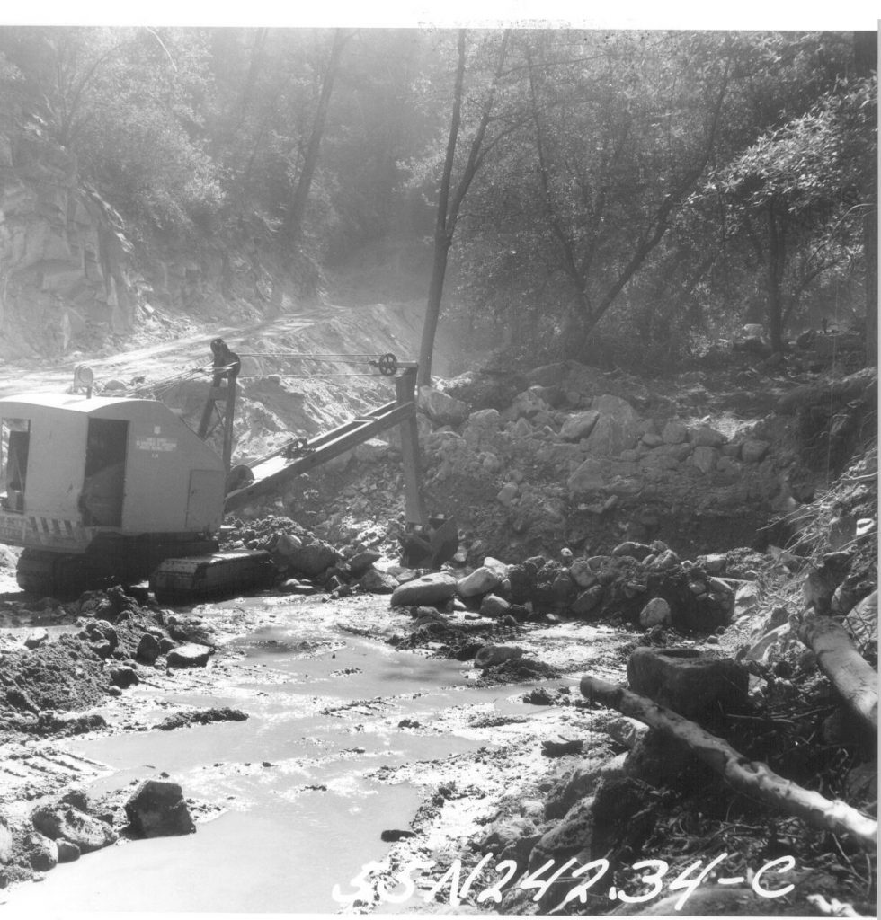
A tractor shovel begins trenching a site for a foundation of a check dam. This spot is located just downstream from Sturtevant Camp.  Circa 1962

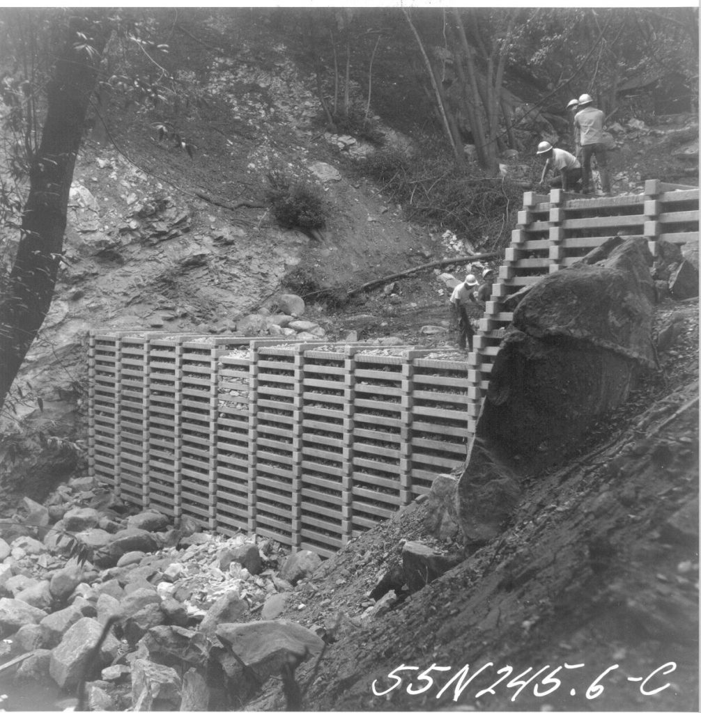
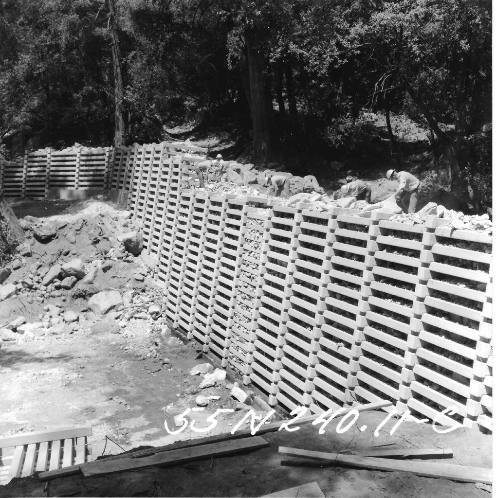
Here are some photos of the Chantry Flats check dams during their construction back in the early 1960′s. The U.S. Forest Service and Los Angeles County Flood Control District teamed up to engineer and construct these Lincoln Log type structures in many of the front country canyons of the Angeles National Forest.  These structures were designed to keep the stream bed’s ever-moving alluvium “in check” with hopes of reducing the accumulation of sand and rock in the Big Santa Anita’s reservoir further down canyon. Regardless of how they’ve performed, they’re here to stay for the foreseeable future.  The paved fire road that you begin your descent down into Robert’s Camp is the beginning of the construction road that was bull dozed all the way past Sturtevant Camp.  Another road was also built on up the Winter Creek and beyond Hoegee’s trail camp.  Today you can still make out the remnant switch backs of the “Burma Road” which climbed up and past Sturtevant Falls.  Look for the non-native Italian cypress, pines and even eucalyptus trees that were planted on the abandoned road bed after the dams were installed.  The Big Santa Anita Canyon Trails Map depicts the location of the abandoned Burma Road.  The map is available at Adams Pack Station or canyoncartography.com    Following the road is a hazardous proposition any time of year, so be especially careful for drop-offs, rattlesnakes, etc.  If you’ve hiked on past Cascade picnic area, you’ll strain to imagine that a road ran through here, wide enough to accomodate cement mixers, skip loaders, cranes and more.

A check dam nears completion at Cascade Picnic Area, Big Santa Anita Canyon. A gunite cap will be added next.  Circa 1963.

The destruction of pristine riparian environments would be unthinkable in our day and age.  Yet, during the late 1950′s, this type of project was considered prudent land management and protection of watersheds.  Essentially, the dams have changed the natural hydraulic grade of much of the Big Santa Anita Canyon and Winter Creek.  The dams have created a stair-step type of profile in sections of the canyon bottom.  Behind each dam are thousands of cubic yards of alluvium (sand, gravels and boulders) that are for now “stuck” in a static location.  One day nature will have her way and there will be a phenomenal movement of material that will wash downstream.  The engineers referred to this material behind each dam as a “debris cone.”  In 1969, an El Nino storm pattern brought torrential rainfall to Southern California.  One night during the ’69 Flood, a number of the smaller “sill dams” blew out.  A sill dam is the lower (smaller) dam that you’ll often see just below or downstream of the larger check dam.  The sill dam’s function is to protect the foundation of the larger check dam.  Anywhere upstream of Cascade picnic area, you’ll notice that all the check dams have their accompanying sill dams.  Anywhere below the confluence of the North Fork, you’ll notice that these sill dams are missing.  Look carefully and notice the exposed foundations of the dams.  One day they may collapse.  This all happened during one set of storms in ’69!  Slowly, nature has been healing from all this damming of the canyon.  Decades later you can see the ivy, black berry bushes, mosses, fallen trees and sharp-edged boulders softening the scene.  Canyon wrens flit back and forth into the aging rip-rap after spring floods ring through the canyons.  Stout, black rattlesnakes gently drape their coils off the edge of the walls of the dams during the warm, drowsy days of August.  The canyon is gradually claiming all the dams.  We’re just hiking and feeling all this. in one part of this long, long timeline.

November, 2015.   I recently heard from Dennis Logue, a member of the construction crew who built both the road and dams starting back in 1958.  We began corresponding.  He graciously has given permission for me to add his memories in the form of several letters to Canyon Cartography, describing the project and some of the colorful characters that were involved.   Here they are:

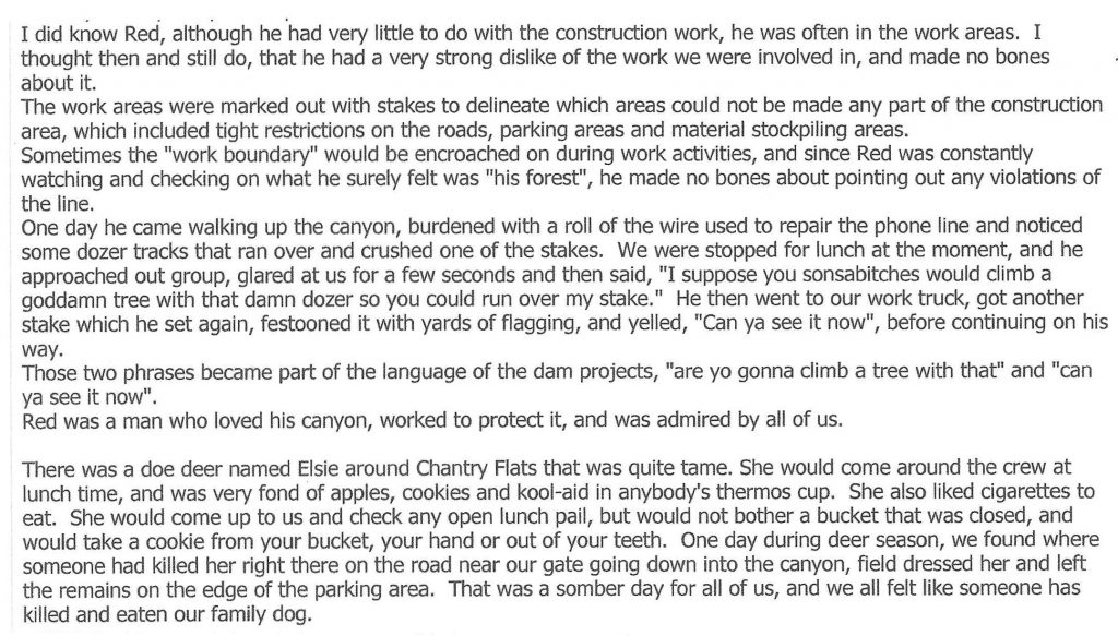
The first letter from Dennis. Red Shangraw & Elsie the deer

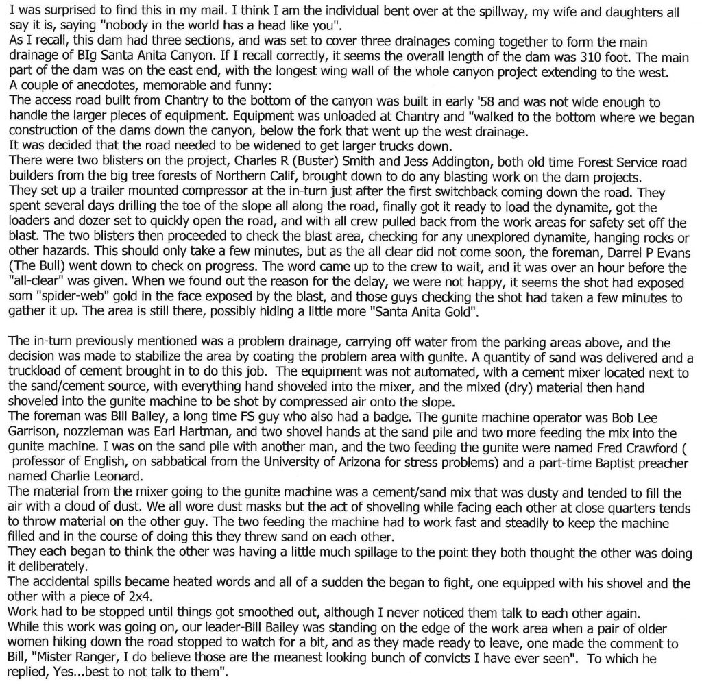
Dennis Logue is seen working on uppermost check dam in Big Santa Anita Canyon. July 1962. He’s the third man out to the left near the future spillway.

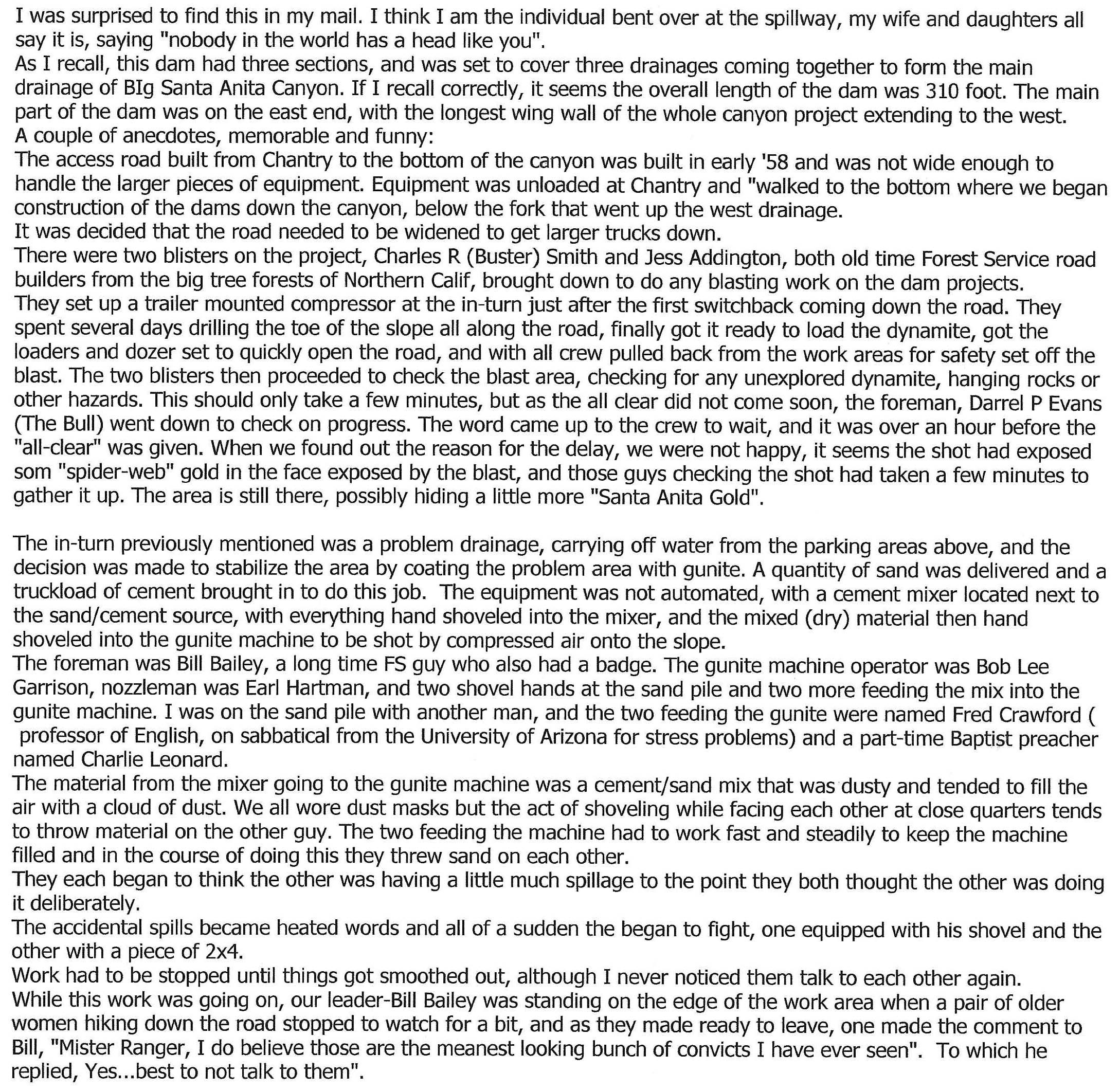
Second letter describing challenge of road building and method of applying gunite.

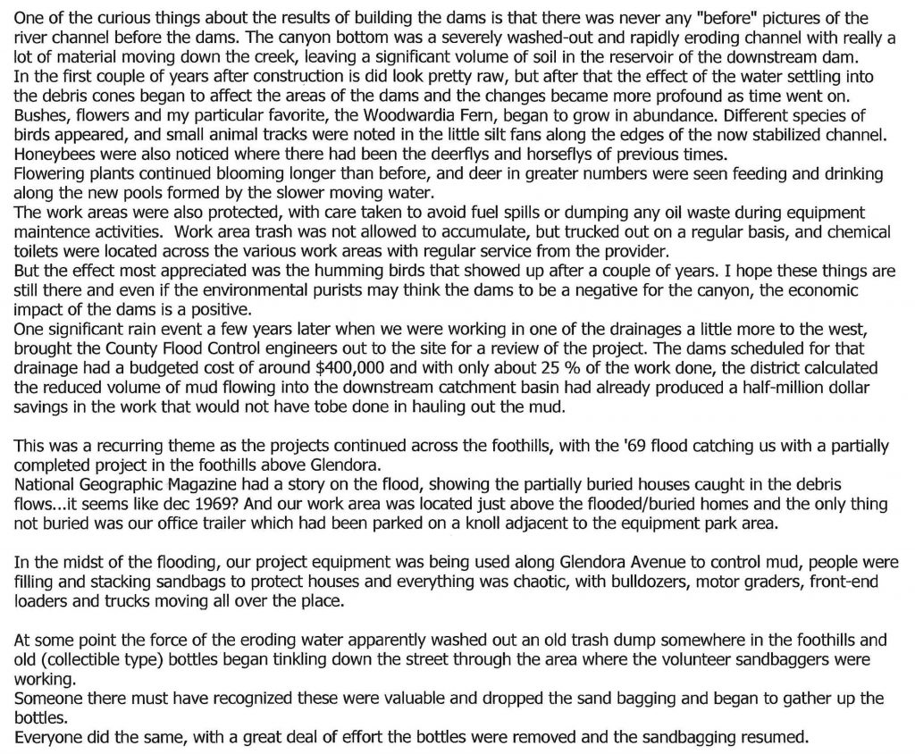
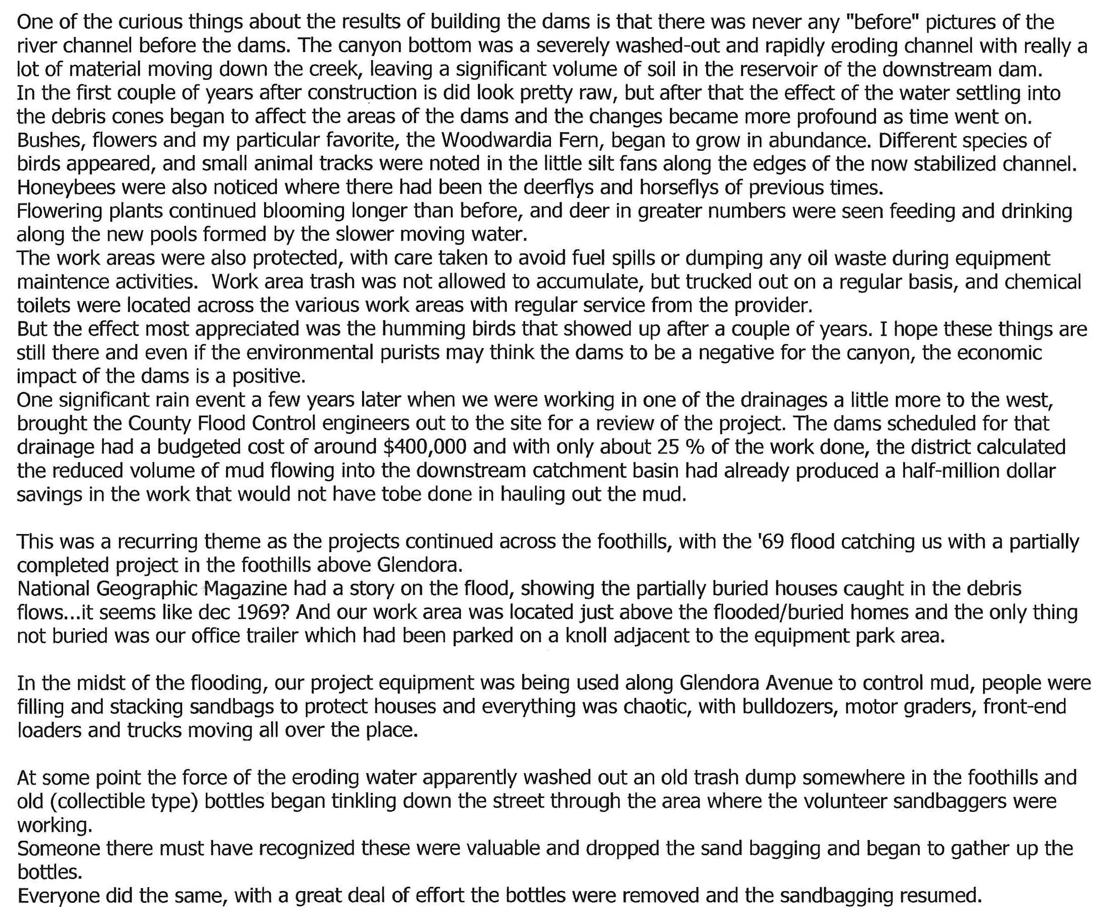
Third letter describing return of riparian plants and local animals. Response to 1969 Flood.

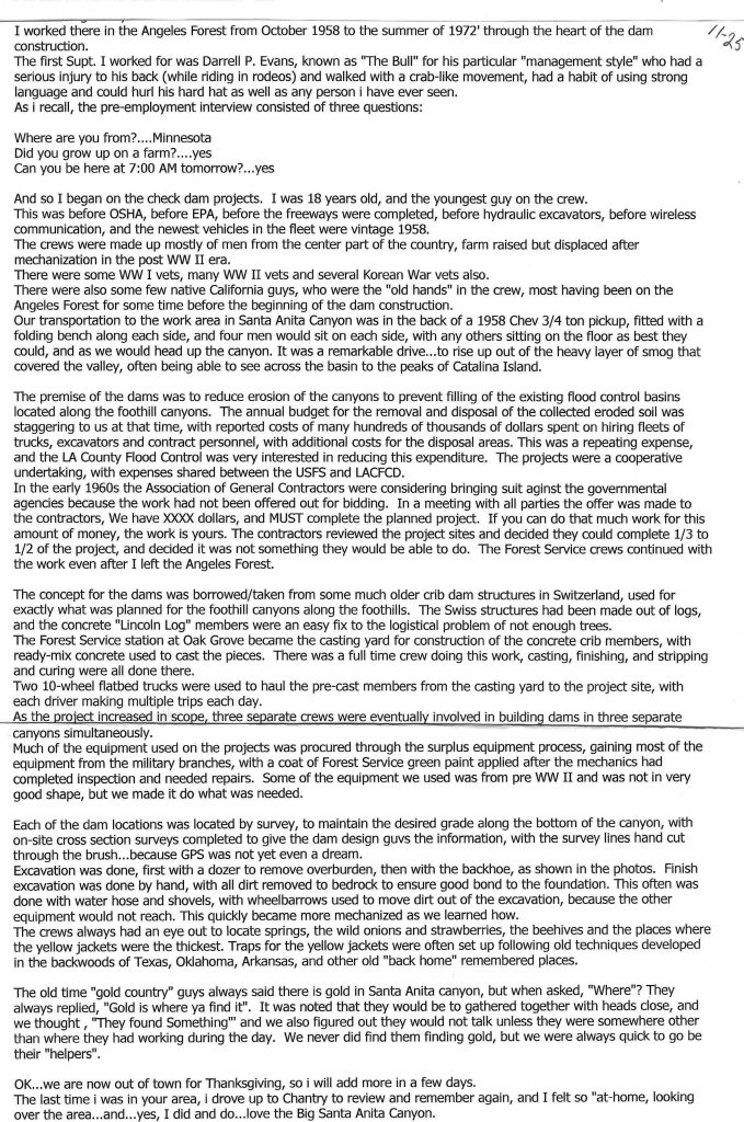
Fourth letter covering Dennis’ experience working with the crew on dams along with details on excavating for check dams.