An Industrious Little Dark-Eyed Junco… Spring Nest Building is Happening in the Big Santa Anita Canyon

Posted on April 17, 2013 – Written by Chris Kasten
A dark-eyed junco gathering nesting materials. Fern Lodge, Big Santa Anita Canyon.

I took this picture of a Dark-eyed Junco a few days ago in the Fern Lodge area.  Just a half mile downstream from Sturtevant Falls, this little female was collecting dried grasses for her nest.  The Big Santa Anita and Winter Creek canyons are filled with bird song from many species of birds.  The habitat where this picture was taken is riparian/woodland, a land of rushing streams, boulders and trees. Perfect for supporting lots of life!

Hiking the Abandoned Burma Road of Chantry Flats

Posted on March 9, 2013 – Written by Chris Kasten

This is a short story about hiking the abandoned Burma Road of Chantry Flats.  You can see the route of this old road on the Chantry Flat – Mt. Wilson Trails Map, available on this website,  or at the Adams Pack Station General Store next to the Chantry Picnic Area. This old road was once the carved out thoroughfare of cement mixers, bulldozers, skip loaders, cranes and more during the construction era of the check dams upstream from Sturtevant Falls.  Today it rests quietly , slowly being reclaimed by the mountains.

It was warm and mild out on the front porch of the cabin.  A gentle breeze woke up the chimes hanging from the eve.  The ringing was calm and faint.  I set down my book, relaxed and yawning in the bright February sunshine.  What to do?  Maybe take a nap if I didn’t start moving or perhaps, hike up to the prominent switchback of the long-abandoned Burma Road.  Only a mile and a half in from Chantry Flats, one can suddenly transport one’s self into a chaparral-clad wilderness of upward climbing.

So, I’m doing this crawl up a gully between two of our neighbors’ cabins.  At first, like everything we don’t know the whole story of, it’s really easy.  Lush, green grasses blow lazily about my boots as I plod upward.  Shaded by blossoming bay trees, the air is sweetened by thousands of the tiny yellow flowers.  Large and stately canyon live oaks begin to make their presence as I climb further and further from the Big Santa Anita Creek.  The slope’s steepness increases and I’m constantly stopping and kicking into the moist, sandy slope.   The one thing that I packed, the one thing that I’d really need for this trip was a pair of smallish pruners, or loppers, for cutting through brush.  These became indispensable as my route began to be impinged upon by dense, dry tangles of brush.  Several times, even the little folding pack saw came out for branches that were over a couple of inches in diameter.  So, my pattern was often moving up the mountain gully a few paces, clipping and sawing, then pushing through the tiny opening to step up a few more paces……  I was soon high enough to see Mt. Harvard out across the Winter Creek Canyon.  Chamise and buckbrush began to make their presence.  This was the really hard going.  Soon I was wading hip deep in black sage, which left its’ signature scent in all my clothing.  Clutching at little twiggy limbs, I pulled myself up the final pitch to the old Burma Road and a fragrant, blossoming patch of rosemary.

Hoary Leaf Ceanothus

This same spot was visited by Richard Loe and I last spring.  However, we had walked and climbed up the decaying switchbacks of the old road near Sturtevant Falls.  That day we ran into three stout, black rattlesnakes gliding through piles of white rocks – all within a couple of minutes!  This time, I was a good month earlier in the season, so rattlesnakes were the last thing on my mind.  From the end of this switchback, I could make out the Pacific Ocean, while Catalina Island appeared to float on the hazy scene.  After drinking a little water and shaking the chaparral fragments out of my clothes, the thought of how to return slowly made its’ way in.  It was a sparkling, dazzling clear day.  All courtesy of the mild Santa Ana winds.  The startling clarity of vistas and the mild temps make Southern California’s mountains a paradise.  I just wanted to stay out in it and make the day last.  One thing for sure, the route back down the gully was doable, yet not what I really wanted to do.  I looked across and down to Sturtevant Falls emerging out a gash in the white cliffs from my unique vantage point.   It was decided,  continue up the abandoned Burma to the where it enters the North Fork and then back down to the Upper Falls Trail.  This would be a great way to make a loop out of my trip.

Close-up of blossoms, Hoary Leaf Ceanothus

There’s brush all over the Burma Road.  In case you’re wondering what this road was all about,  you can read a blog I wrote earlier on about the building of the check dams.  Entitled, “How Did All These Dams Get Here?”   The abandoned Burma Road shows up on the Big Santa Anita Canyon Trails Map.  On I hiked, weaving through sumac, sage, yuccas, non-native pines and eucalyptus (planted by the Forest Service), manzanita and more.  At one point I got mixed up and wandered off on some kind of spur road that must have dead ended.  However, before that was figured out, the sumac was chest high and the beating through the brush had become relentless.  There was a beautiful scene that just had to be photographed.  It was a hoary leaf ceanothus (Ceanothus crassifolius) also more commonly referred to as buckbrush or wild lilac.  One of the great things about the hoary leaf variety is that there are no thorns to be reckoned with!  This shrub blooms usually from January through April and emits a sweet, sugary fragrance from its’ myriad tiny flowers along the branchlets.  Right now, you can see lots of this beautiful plant blossoming on the slopes across the canyon from Chantry Flats.  Not long after this, I was once, again, wading through the brush when I heard a dull, flat hiss coming from the ground near my left boot.  It couldn’t be….  I looked down and saw an irregular opening in a boulder lodged in the ground.  Perhaps a brother or sister of the Crotalus genus had been startled by my careless wandering…  Time to back straight out and look for where the road really ran.  It had been since 1977 or 78 when Howard Casebolt and I followed this same section of the road, so now it all seemed so new and fresh!  Fortunately, I found where the road made a sharp hairpin and was soon on the right track.  There were road cuts that were so deep (25-30 feet high) and narrow that the road was cool and damp.  Gooseberry bushes even liked these spots.  Dark green, plump grasses lay down in these dark, secret places.  Eventually, I walked and scrambled along the road’s remains in the area I call the “Great White Scar,” visible not only from Chantry Flats, but much of the San Gabriel Valley below when you look up the mouth of the Big Santa Anita.  Although the sun was nearly over the ridge by now, heat radiated out from the plane surfaces of jagged, white rocks.  Thoughts of large, anxiety-ridden serpents occasionally filled my mind as I continued to hop from rock to rock and beating back more brush.  Eventually I made my way to the large pine flat just above the North Fork confluence near cabin #94.  Whew!  The one thing I didn’t bring and began to wish I had, was a flashlight.  Soon I was scrambling down the side canyon to the Upper Falls Trail in the gray and failing light in the canyon bottom.  Arriving at the cabin, I chuckled to myself just how pivotal one’s decision to take a nap or go for a “little” hike can be.

American Dippers in the Big Santa Anita Canyon – Something to Watch for on Your Next Southern California Waterfall Hike

Posted on February 8, 2013 – Written by Chris Kasten

As you wander along the banks of the Big Santa Anita or perhaps its’ tributary canyon the Winter Creek, watch for the water-loving dippers.  Known as American Dippers or Water Ouzels (Cinclus mexicanus), these small birds hop from rock to rock and true to their name, dip their heads and bodies down into the rushing stream in search of food.  The Dipper does this squatting dance, bobbing its’ body up and down, up and down, before flying off low over the water.  If you’re lucky enough to watch one swim, you’ll notice how similar these enchanting creatures are to ducks.  Sometimes they’ll thrust their head down into the current, other times they’ll dive down completely vanishing into pools and small rapids.

American Dipper (Cinclus mexicanus)

Dippers have an extra eyelid to help with seeing underwater, much like having built-in goggles!  Their food, at least in the Big Santa Anita creek, consists of dragonfly nymphs and caddisfly larvae.  To help stay warm, these birds secrete oil, helping to keep their feathers and skin glossy and water repellant.Listen for their song as you hike along.  It sounds like a high pitched whistling or trill, repeated over and over.   Photos and drawn diagram courtesy of Bing Images.  


Light Rains Are Gradually Bringing Back Up The Big Santa Anita Canyon’s Stream

Posted on January 18, 2013 – Written by Chris Kasten
A tranquil pool just upstream from Sturtevant Falls, Big Santa Anita Canyon.

A series of recent rain storms, albeit gentle ones, are helping to bring the Big Santa Anita Canyon and Winter Creeks back up a bit.  As of mid-January, we still haven’t seen any big storm systems hit the San Gabriels.  Generally, a larger storm for the Chantry Flats area and most of the front-country, would be anywhere from 6 to 12 inches of rain…. or more.   Back when I worked at Sturtevant’s Camp, there was an old L.A. County Flood Control rain gauge out at the heliport.  It was a great spot for getting accurate reads of storms since there were no overhanging branches from the dense trees to throw off the true amount of water coming down from the sky.  I had a chance to record 20 years of rainfall totals, and it was interesting to say the least!

The driest years were in the neighborhood of 11 (2002)to 20 inches total at Sturtevant Camp’s 3,200′ elevation.  The wettest ones broke the 90 inch mark (2004-2005).  Average years tended to be somewhere between 40 to 55 inches of accumulation.  The snow level in the Big Santa Anita and Winter Creek Canyons tends to around 4,000′ up.  So, at Sturtevant’s, while snow did occasionally fall, mostly what I experienced was cold, hard rain.  It’s rain and snow, percolating down through the fractured and porous aquifer, that sustains our year-round stream.  Although many side canyons only flow seasonally, the Big Santa Anita and Winter Creek flow throughout the driest of years.  The watershed below Mt. Wilson is made up of myriads of steep, twisting canyons and all aspects of slope.  This steep and tumbling country, heavily wooded,  has an extensive surface area that can collect moisture  and store it for years.  A number of Angeles Forest trail maps that depict the routes up and around Mt. Wilson are available online, at outdoor retailers and the Adams Pack Station.  It’s a good time to get out and explore this beautiful mountain.

Hopefully, some big storms are on their way!  We’ll be glad this coming summer if it’s to be…

Rain Caresses the Big Santa Anita Canyon

Posted on December 6, 2012 – Written by Chris Kasten

“Rather the flying bird, leaving no trace, than the going beast marking the earth.”

– Fernando Pessoa

Early winter grass in the late afternoon sunlight. East Fork of Big Santa Anita Canyon.
Concentric circles from rain drops. Fern Lodge, Big Santa Anita Canyon.

I am only hiking through these Santa Anita Canyon Trails.  Watery, green and dusky in slowly fading light.  My energy is concentric and light, gently touching all that is around.  Yours is also reaching all around that place known as here and now.  Bounce, yeah’ that’s it!  Your circle touches mine and then they vanish.  Maybe, just maybe…. it’s all circle energy bumping up against other circles… endlessly.  Let our circles gently merge this day, this day which will never quite be the same ever, again.
The circle of the sun sends it’s warmth and visible light to our roundish earth, turning and turning in the circles of days.  Our time in the canyons, that sacred time, albeit brief – comes back to us in circles of memories that connect us to this earth – our only home.  Today I’ll feel this place, this place within and this place without.  The two merge and are no longer two.  The illusion of the you and I, that and this, then and now blending to one whole.  The daylight grows shorter, just a bit, each day as we approach winter solstice.  May the light and darkness help me to find my way home.

Our Stream is Well and Alive, Big Santa Anita Creek

Posted on October 27, 2012 – Written by Chris Kasten
Coast Range Newt, Fern Lodge, Big Santa Anita Canyon.

“I’m digging this place!  Look at me and you’re looking back, way back.”

This Coast Range Newt (Taricha torosa torosa), also commonly known as a salamander, is loving the moisture from our recent rains this last weekend.  Look for these fascinating creatures along the streams during the wet months of the year, October through April.  Try to keep an eye out while hiking and biking just after storms, since they’ll often be crossing the trails and tend to blend in with the soils around them.

Fall Is On Her Way In the Big Santa Anita Canyon

Posted on October 3, 2012 – Written by Chris Kasten

Dried flower stalks of Chamise, a fire indicator species found throughout much of the chaparral plant community.

We’re only about two weeks into the autumn season and the Big Santa Anita Canyon is giving us all kinds of hints of change.  When you hike by cabin #23, just above Roberts’ Camp, you’ll see an expanse of yellow-tan bay leaves all around the place.  If it’s later in the day, the scene seems to create a warm glow of its’ own.  Many maple leaves are on the ground as well, due especially to the extreme dryness of the soils.  Many of the plants here are members of the chaparral plant community, drought tolerant to say the least.  Just go a short distance upslope from any stream bottom and you’re quickly in a world of prolonged heat and dryness, especially on south and west facing slopes.  Pictured here are three examples of plants commonly found along our trails that radiate out of Chantry Flats.  Chamise, poison oak and buckwheat have been transitioning into their fall colors for a month or more.  If you’re bouldering down among the lower reaches of Big Santa Anita’s East Fork, the stream channel is choked with the delicate, crisp leaves where water hasn’t ran in months.  When a tree squirrel runs and jumps through this scene, it can startle you with thoughts of bears and deer ambling along.

The water flowing over Slider Rock is a narrow, slick thread of stream.  The creeks that still flow are only a whisper of their former selves.  Hiking along, even in the evenings, there’s hardly any stream sound at all.  Once in awhile you’ll hear a deep gurgling of water in nocturnal hollows, reminding you that our stream’s well and alive.  That this has happened before, perhaps thousands and thousands of autumns past.

Poison oak leaves turning crimson in the fall.
Buckwheat flower stalks. Soon, these flowers will turn to a rusty red color for the duration of autumn and winter.

In the weekend mornings, as droves of hikers and mountain bikers make their way up and down the main canyon, watch the talc-like dust hang in the sunlit air above and about the trail.  Motes of thick gold light illuminate and hold still in your mind the hanging dust particles that surround the hikers moving past.  Ivy leaves and blackberry bushes are covered in the dull patina of trail dust.  There’s only one solution for this scene…. and it’s coming soon I hope.  I gave up long ago forecasting the likelihood of a dry or wet winter on its’ way.  Big acorns, little acorns or no acorns at all make no difference to me.  So, no guesses here.  Yet, I can hope for the quenching drink of early winter rains.   There’s even room for the dreams of thick snows blanketing the dark, hidden slopes of the upper reaches of the Winter Creek and Big Santa Anita Canyons.

There are no Santa Ana winds gusting quite, yet….  They’re on their way.  For now, we’ll live in the still hush, the holding pattern, until the winds and rains come.


Chantry Flats Crank Telephone System

Posted on September 14, 2012 – Written by Chris Kasten

Phone line and insulator detail of crank telephone system. This location is at the top of Sturtevant Falls on the Upper Falls Trail.

Have you ever wondered what that green wire is running from tree to tree along the trails at Chantry Flats?  That green wire is part of the Chantry Flats crank telephone system over six miles in length.  This remnant phone system goes back to a much earlier time in the Angeles National Forest’s history; a time when the Angeles Crest Highway had yet to be built and trail resorts were thriving during the “Great Hiking Era.”  It was a time when much of southern California was still agricultural and hikers often took the Pacific Electric red cars (trolleys) to trailheads before embarking upon the multitude of paths in the San Gabriel mountains.

The crank telephone system connected most of the old trail resorts, such as Hoegees, Sturtevant’s, Roberts’, Fern Lodge and First Water Camps in the Big Santa Anita Canyon.  Many of the private cabins were also connected to the phone system, not to mention Guard Stations manned by the U.S. Forest Service.  The phone line also ran into the “backcountry” to places like the West Fork of the San Gabriel River and Coldwater Canyon near Strawberry Peak.  It went to Mts. Wilson and Lowe, up and down the Arroyo Seco Canyon and other canyons too numerous to include here.  In short, the crank telephone system was a vibrant, reliable form of communication for a time gone by.

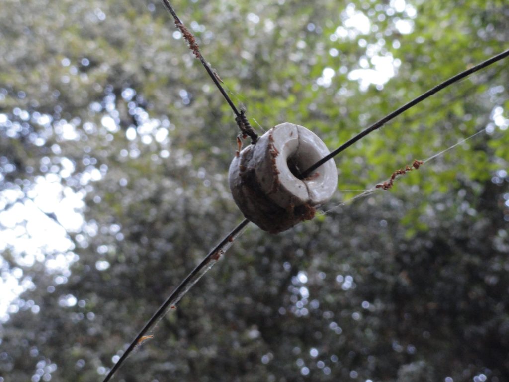
Split ceramic insulator carrying the 12 gauge phone line. Upper Falls Trail, Big Santa Anita Canyon.

Nowadays, in canyons other than the Big Santa Anita and Winter Creek,  you’d never know where to look for evidence of this historical technology in the Angeles’ early days.  If you’re hiking up the Sturtevant Trail toward Mt. Wilson, look for a number of remnant split ceramic insulators still dangling on rusted wire from the oak trees not far up canyon from Sturtevant’s Camp.  In some cases, you can see where the white, round insulators that used to be nailed directly into tree trunks are now being consumed by the still growing trees.  Just a nubbin of an insulator still protrudes from trunks of oak and spruce, sort of appearing the way a white spool of thread might appear if you looked  at it “on end.”  It’s center attachment nail long corroded and missing.

The phone line in the Big Santa Anita currently travels between the Adams Pack Station at Chantry Flats down to First Water and  then up stream to Sturtevant’s Camp four miles north and west of there.  Another section of line branches off from Roberts’ Camp, which is where the hikers’ footbridge is located.  From there, the line goes up the Winter Creek to a spot just up stream from Hoegees Campground.  The line travels from tree to tree, supported by ceramic insulators.  The line itself is 12 gauge and uninsulated, its’ core being made of steel for strength with a surrounding jacket of copper for conductivity.  Connections between sections of wire are made with “butt-in” style connectors made of brass which are crimped into place.  These connectors look like narrow little barrels that the line slides into before it’s crimped half way in.  The next section of line is slid into the other half of the barrel and crimped as well for an airtight and, hopefully corrosion-free seal.

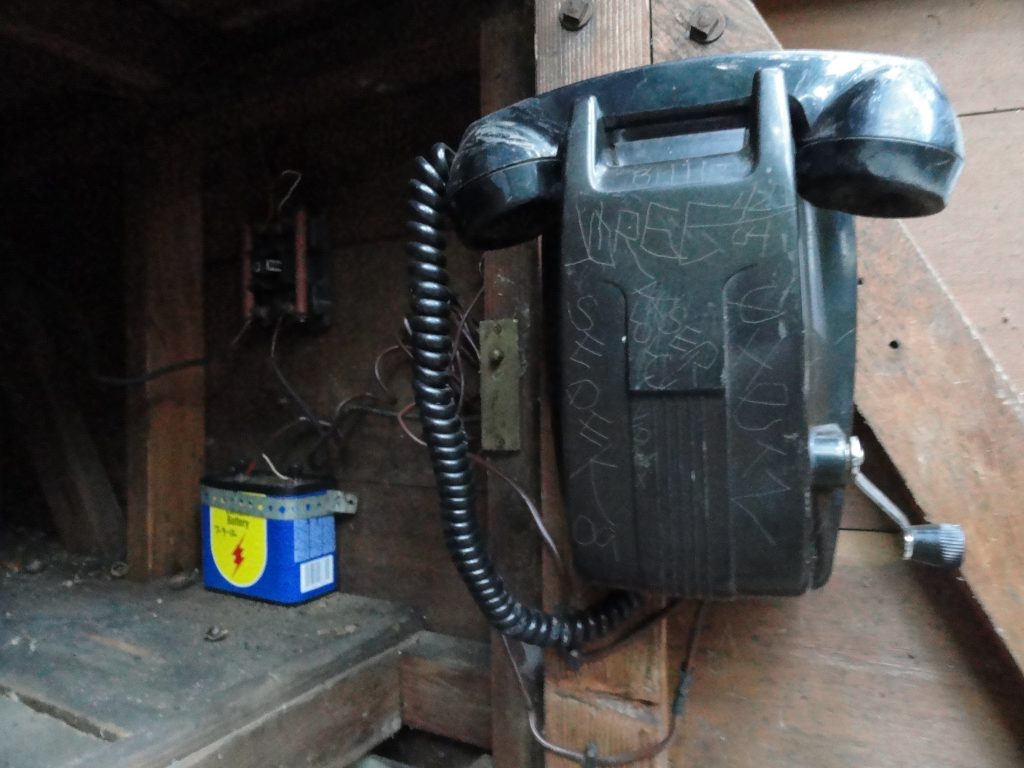
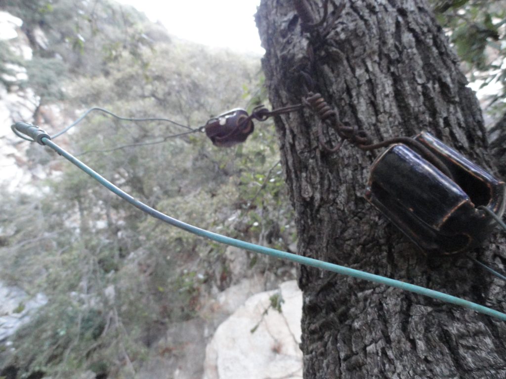
Crank telephone and battery in call box #8, Upper Falls Trail, Big Santa Anita Canyon.

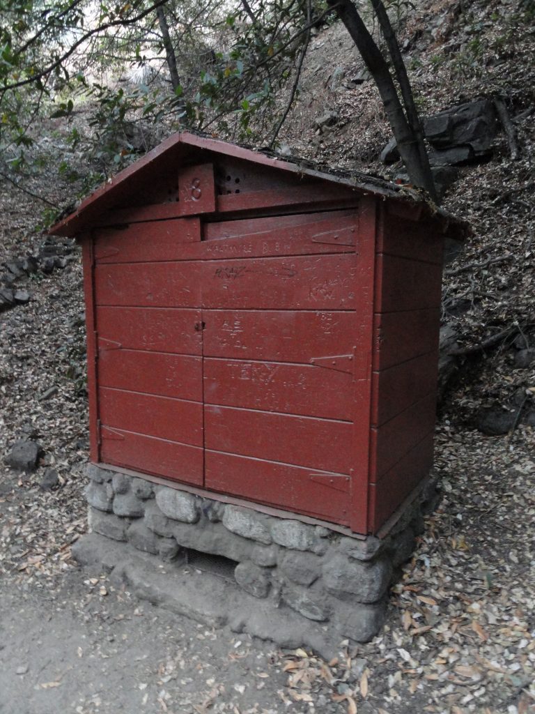
There are currently nine call boxes located alongside the trails with crank telephones and batteries in them.  These call boxes are for emergency use, such as the reporting of fires or medical emergencies.  The locations of these call boxes appear on the Big Santa Anita Canyon Trails Map by canyon cartography.com.   A fair number of the cabins that you see along the trail also have crank telephones as well.  You might be wondering just how one makes a call from one of these antique phones.  Since there’s no dial at any phone, what you do is send a pattern of “rings” from your location that will tell the recipient of your call if the message is for them or not.  For example, the Pack Station is “one ring”, Sturtevant Camp is “two rings” and any private cabin would be “three rings.”  This is known as a party line and was quite common in rural areas of the United States up until the 1950′s and early 60′s.  A ring is created when the crank handle located on the phone is turned rapidly as possible to generate voltage.  (the crank handle is connected to a 2, 3, 4 or 5 bar magneto)  So, say you’re calling a private cabin owner, you’d crank the handle vigorously several turns, pause…., then crank several turns, pause…, then several more turns.  Now, stop cranking and just listen.  Be patient.  Chill out and wait a good minute for your party to pick up on the other end.

Call box #8, Upper Falls Trail, Big Santa Anita Canyon.

On a crank telephone, your voice is carried by battery power.   There’s no need to keep cranking a phone when speaking – only to ring someone.  Each phone is protected by a carbon block lightning protector.  You’ll notice that the call boxes along the trail also have a 6 volt lantern battery attached to the phone.  Originally, the phones were intended to operate on 3 volts, not 6.  The batteries were cylindrical, dry cell 1 volt types in series.   It seems that for decades now, we’ve been using the lantern batteries without damage to the phones.   Also another detail in regard to this type of system is that there’s only one wire traveling from tree to tree.  All phone systems have a circuit that must be completed, thus the wire pair we’re all so used to seeing.  So, where’s the other half of the wire pair?  It’s the earth.  Each phone or call box must be grounded some how.  Sometimes there’s a ground rod driven into the earth for this purpose, other times there’s a bare wire going into the stream or a ground wire’s attached to a cold water pipe.  Good grounding’s important if you’re going to have a clear pathway for your phone to work and to be easily heard.

The call boxes that you see along the trails were built by the U.S. Forest Service back in the 1940′s, just after World War II.  Each call box not only had a phone, but a water pump with a suction strainer and fire hose.  There were also McClouds, shovels and other fire fighting tools.  Back in the 40′s, 50′s and 60′s, it was expected that members of the recreating public be willing and able to fight wildfire if the need arose.  The Forest Service also maintained the phones and phone line, climbing trees and restringing wire as necessary.  Unfortunately, with budget cutbacks constantly hacking away at the Angeles’ operating costs, phone repair fell by the wayside.

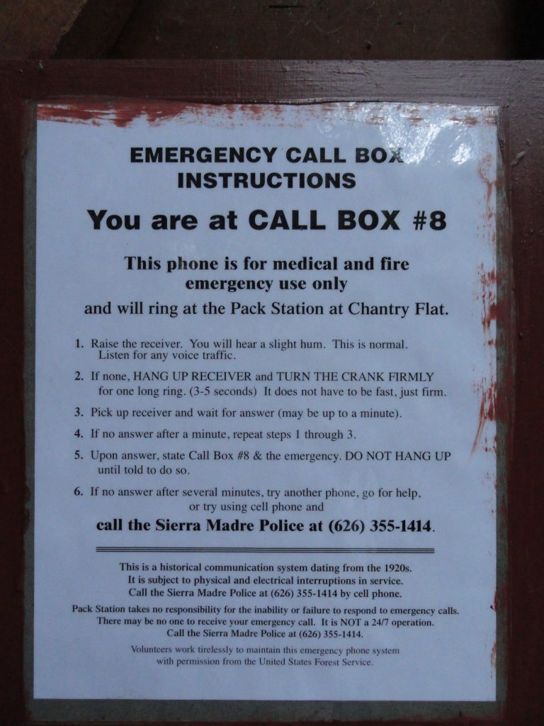
Operating instructions for the Chantry Flats crank telephone system. Call box #8.

Fortunately, the Big Santa Anita Canyon Permittees Association, comprised of concerned cabin owners, took over the maintenance of the crank telephone system.   This rural phone system is truly a last remnant of an earlier time in Southern California’s San Gabriel mountains.
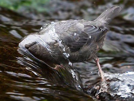
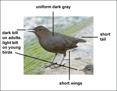
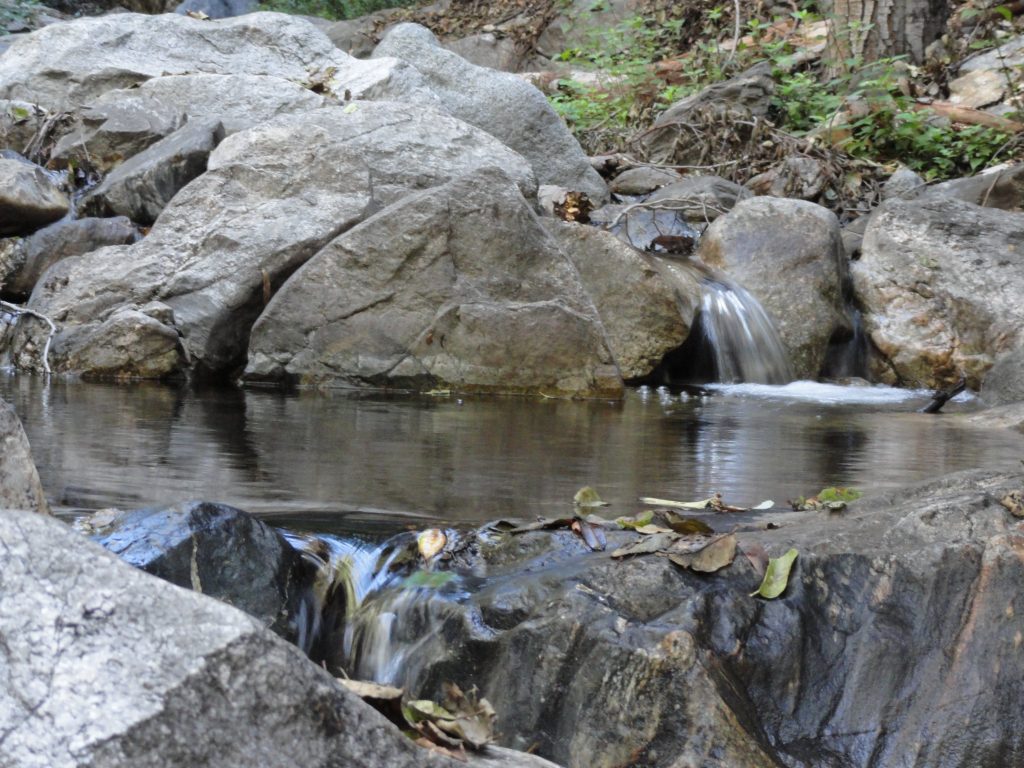
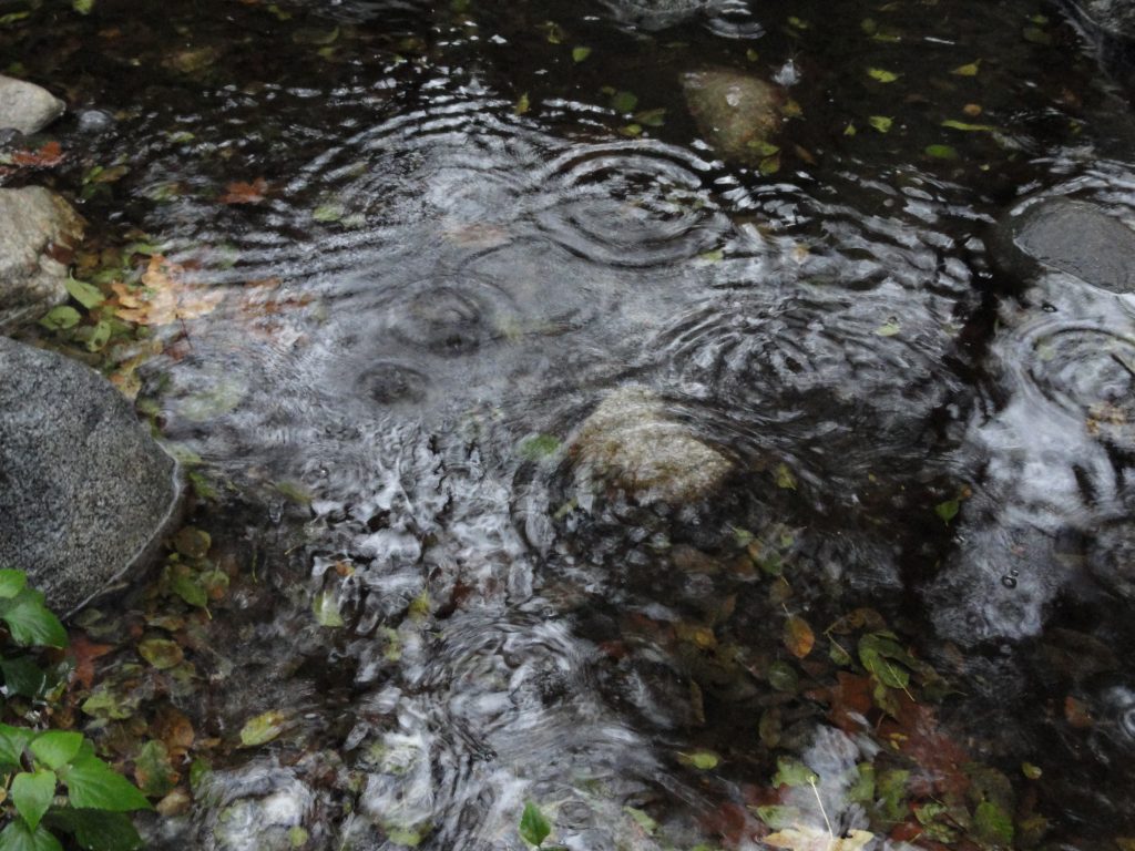
California Black Bears Coming Further Downslope For Water, Big Santa Anita Canyon is Getting Dry

Posted on August 1, 2012 – Written by Chris Kasten

The San Gabriel mountains provide habitat for black bears (Ursus americanus californiensis) throughout the year.  The accompanying photo was taken through the screen door of a cabin at Fern Lodge just before dark.  These elusive animals are seldom seen along the trails that radiate out from Chantry Flats.  As a rule, bears will avoid contact with humans if given the chance.  However, in the aftermath of a light winter, streams in many of the smaller side canyons are now drying up.  This causes much wildlife, including bears, to drop down to lower elevations in search of water.  The Big Santa Anita and Winter Creek flow throughout the driest months (September-October-November), becoming the primary source of drinking water for all creatures.

A resident black bear makes his / her way down the slope directly behind cabin #63 in the Fern Lodge area.

Bears are omnivorous, seeking both plants, insects (grubs and ants) and occasionally small game for food.  Right now, their scat can be seen alongside the hiking trails.  One of the black bear’s mainstays is manzanita berries, which can be seen abundantly throughout their scat.

Black bears although shy, are very powerful.  They are tree climbers and can quickly scale the steepest hillsides if necessary.   On the descent, they’re a bit slower and clumsy.  As for shelter, bears den in naturally occurring voids of rock and soil.   Winter conditions in the San Gabriel mountains are quite mild in contrast to other North American mountain ranges, so deep hibernation is not a part of the local black bear’s lifecycle as it might be further north.  Therefore, it’s possible to see a bear any month of the year!

An adult grizzly bear far, far away from Big Santa Anita Canyon. The San Gabriel mountains had a grizzly population up until the last one was shot in Little Tujunga Canyon in 1919.

There was a time once when another species of bear roamed the San Gabriels.  This was the Grizzly, (Ursus arctos horribilis) now extinct throughout California.  Grizzly bears were known to many backcountry travelers of the 19th century as X bears, due to the hourglass shape of lighter colored fur on their backs.  When the grizzly bear was aggravated, the light colored fur would stand straight up, sort of the way that dogs do when upset.  You can read more about this time of grizzly bears roaming the San Gabriels in John W. Robinson’s “The San Gabriels, Southern California Mountain Country.”

If you are fortunate enough to see a bear in the Big Santa Anita Canyon or Winter Creek, keep your distance and calmness.  Should one approach you, stand tall and hold your ground.  Clap your hands together and yell as loud as you can to scare it off.  Chances are he or she just didn’t see you until your closing distance narrowed way down.  Although a bear’s eyesight is not terribly keen, its’ sense of smell is acute.  While camping up at Spruce Grove or Hoegees campgrounds, hang your food well out on a tree limb at night.   Generally, try to keep your food bag at least 8′ up from the ground and 8′ out from the main trunk of the tree.  A bear-proof food storage canister is really the best way to go and a lot easier than finding the perfect tree.    Keep your campsite clean and wash your dishes well.  No food should ever be stored inside your tent!  Remember, bears are afraid of humans, yet will do just about ANYTHING for food.

Brown Trout in Big Santa Anita Creek

Posted on July 20, 2012 – Written by Chris Kasten

Here’s an image of a brown trout in Big Santa Anita Creek.  While hiking along the Big Santa Anita Creek or Winter Creek, occasionally you might happen upon a fly fisherman working one of the pools that dot our beautifully shady canyon.  This picture was taken just last Tuesday at the base of a check dam between Roberts’ Camp and Fern Lodge Junction.  After being caught, this Brown trout was safely released back to its’ pool without any harm to it at all.  Brown trout, Salmo trutta, are not native to the Big Santa Anita Canyon.  It’s close cousin, the German Brown, can be found in the east and midwest sections of the United States.  This species of trout tolerates water temps between 60-65 degrees, so is especially well suited for our canyon’s stream.  Brown trout were introduced to the canyon years ago and continue to still survive the endless cycles of drought, interspersed by occasional El Nino induced deluges during winter months.

Brown Trout in Big Santa Anita Creek

From the Chantry Flats’ Gabrielino trailhead, just head down the paved fire road to Roberts’ Camp or take the First Water trail to down to the stream midway between Roberts’ Camp and Hermit Falls.  Following any of the stream side trails, watch for Brown trout in some of the deeper, protected pools that offer some form of overhanging protection for fish.  Brush growing up to and over a pool’s surface, submerged logs and dark, rocky underwater hiding places are types of habitat that these fish can be found.